Sir John Monash, Personal Files Book 13, 1 July - 16 August 1916, Part 14
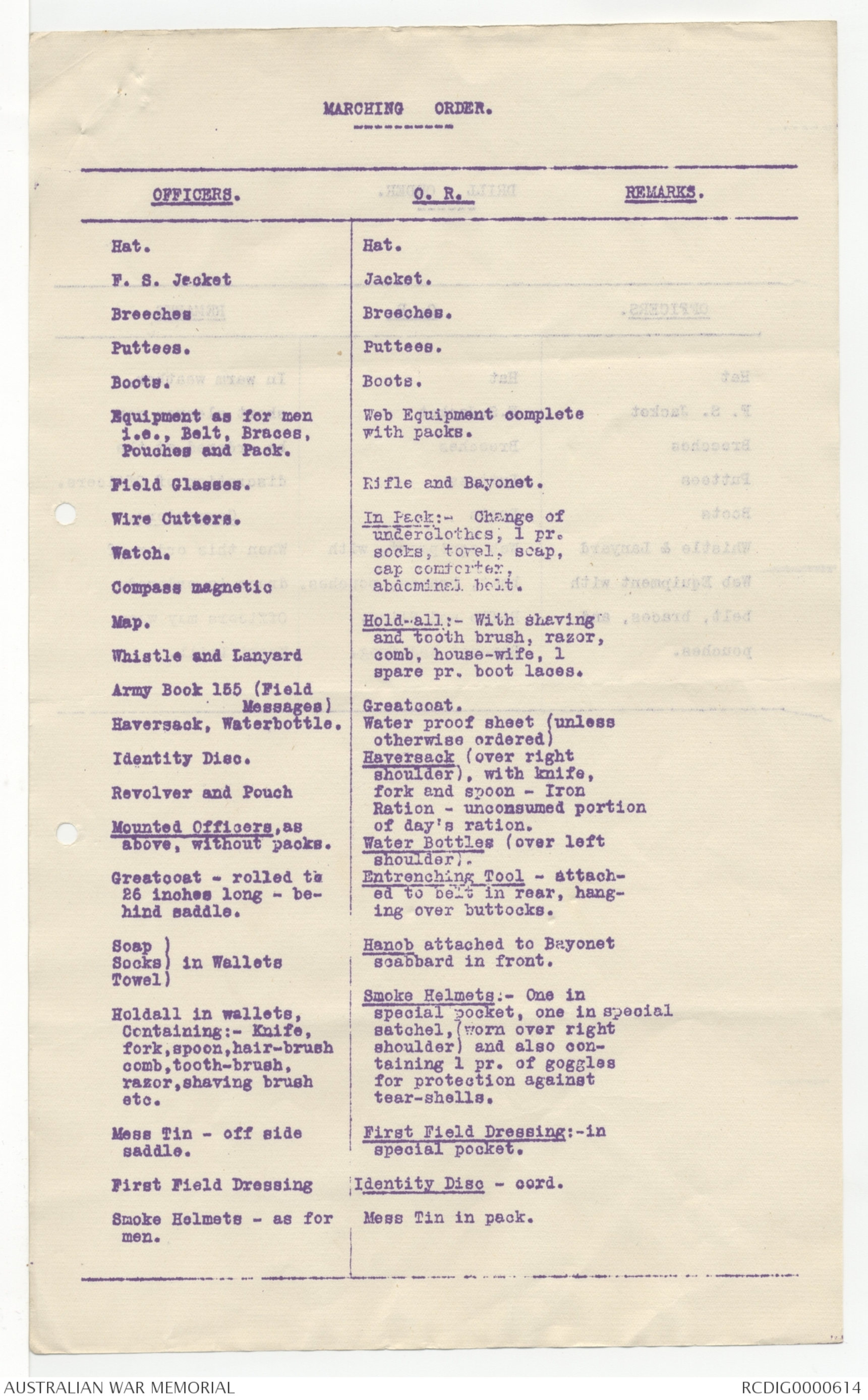
MARCHING ORDER.
| OFFICERS. | O. R. | REMARKS. |
|
Hat. F. S. Jacket Breeches Puttees. Field Glasses. Wire Cutters. Watch. Compass magnetic Map. Whistle and Lanyard Army Book 155 (Field Haversack, Waterbottle. Identity Disc. Revolver and Pouch Mounted Officers, as Greatcoat - rolled to Soap ) Holdall in wallets, Mess Tin - off side First Field Dressing Smoke Helmets - as for |
Hat. Jacket. with packs. Rifle and Bayonet In Pack:- Change of Hold-all:- With shaving Greatcoat. Water proof sheet (unless Haversack (over right Water Bottles (over left Entrenching Tool - attached Hanob attached to Bayonet Smoke Helmets:- One in First Field Dressing:-in Identity Disc - cord. Mess Tin in pack.
|
|
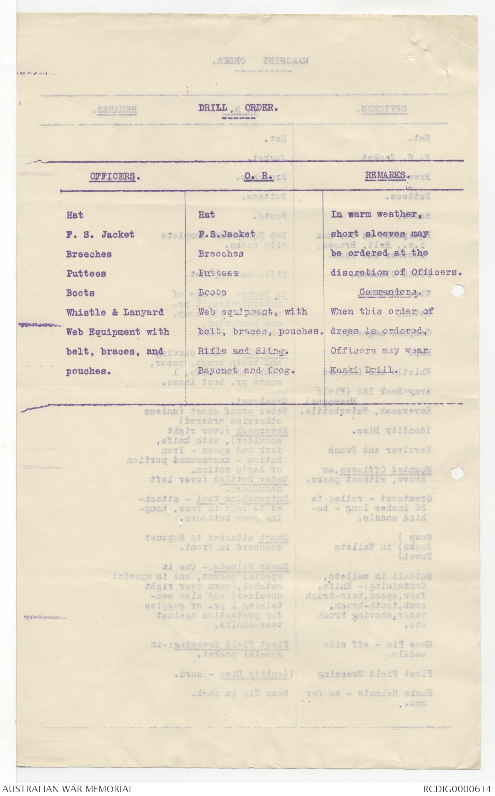
DRILL, ORDER.
| OFFICERS. | O.R. | REMARKS. |
| Hat F.S. Jacket Breeches Puttees Boots Whistle & Lanyard Web Equipment with belt, braces, and pouches. |
Hat F.S. Jacket Breeches Puttees Boots Web equipment, with Belt, braces. pouches, Rifle and Sling. Bayonet and frog. |
In warm weather, short sleeves may be ordered at the discretion of Officers. Commanders. When this order of dress is ordered, Officers may wear Khaki Drill. |
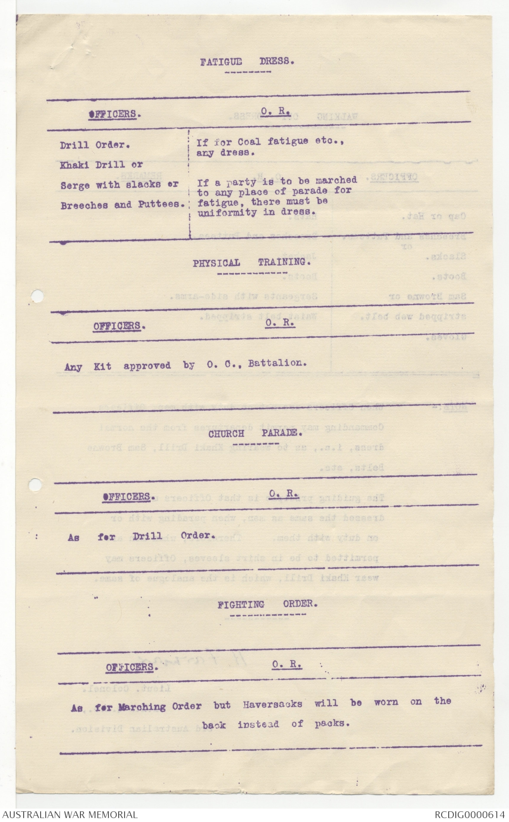
FATIGUE DRESS.
| OFFICERS. | O. R. |
| Drill Order. Khaki Drill or Serge with slacks or Breeches and Puttees. |
If for Coal fatigue etc., any dress. If a party is to be marched to any place of parade for fatigue, there must be uniformity in dress. |
PHYSICAL TRAINING.
| OFFICERS. O.R. |
| Any Kit approved by O. C., Battalion. |
CHURCH PARADE.
| OFFICERS. O.R. |
| As for Drill Order. |
FIGHTING ORDER.
| OFFICERS. O.R. |
| As for Marching Order but Haversacks will be worn on the back instead of packs. |
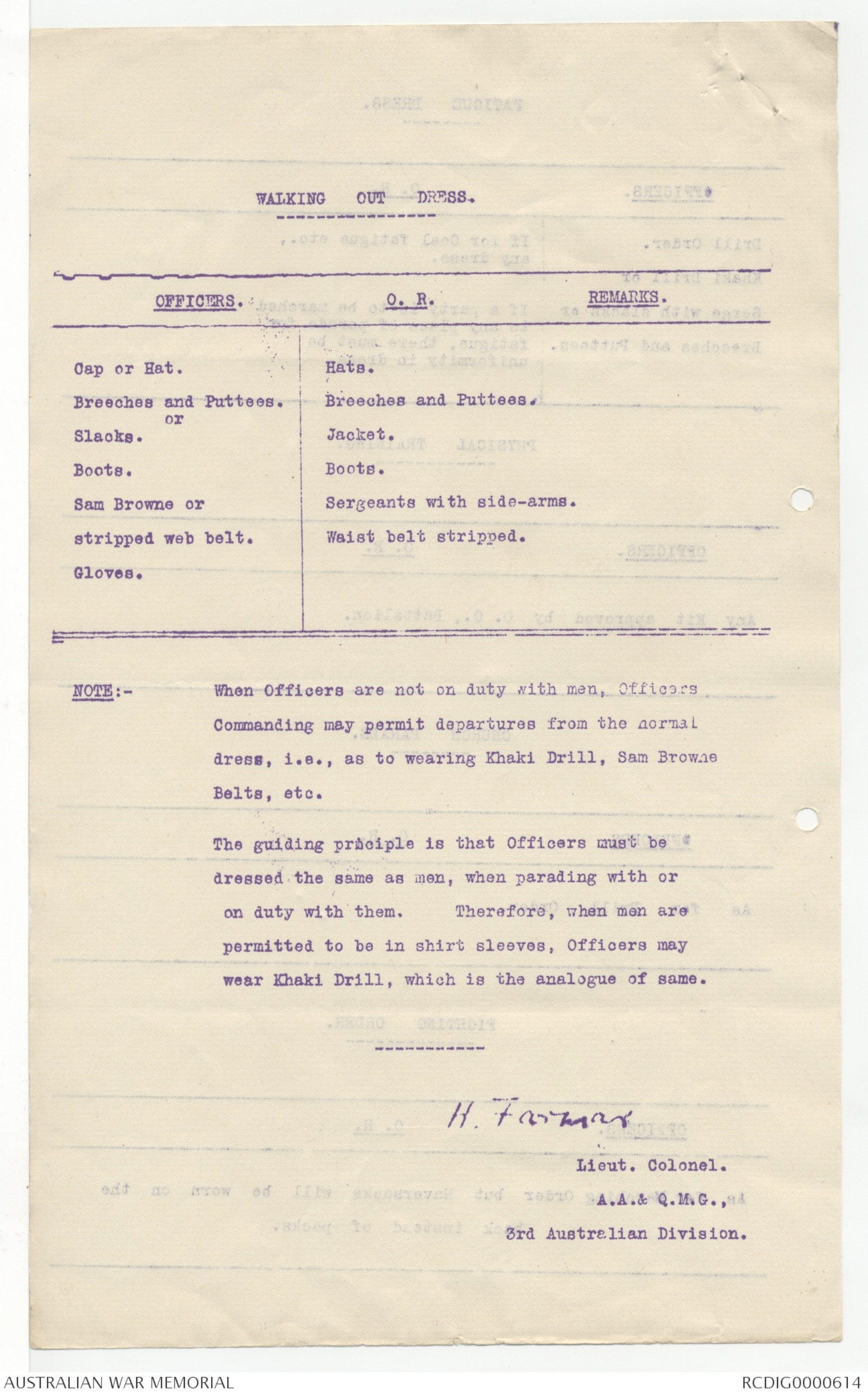
WALKING OUT DRESS.
| OFFICERS. | O.R. REMARKS. |
| Cap or Hat. Breeches and Puttees. or Slacks. Boots. Sam Browne or stripped web belt. Gloves. |
Hats. Jacket. |
NOTE:- When Officers are not on duty with men, Officers
Commanding may permit departures from the normal
dress, i.e., as to wearing Khaki Drill, Sam Browne
Belts, etc.
The guiding principle is that Officers must be
dressed the same as men, when parading with or
on duty with them. Therefore, when men are
permitted to be in shirt sleeves, Officers may
wear Khaki Drill, which is the analogue of same.
H. Farmer
Lieut. Colonel.
A.A.& Q.M.G.,
3rd Australian Division.
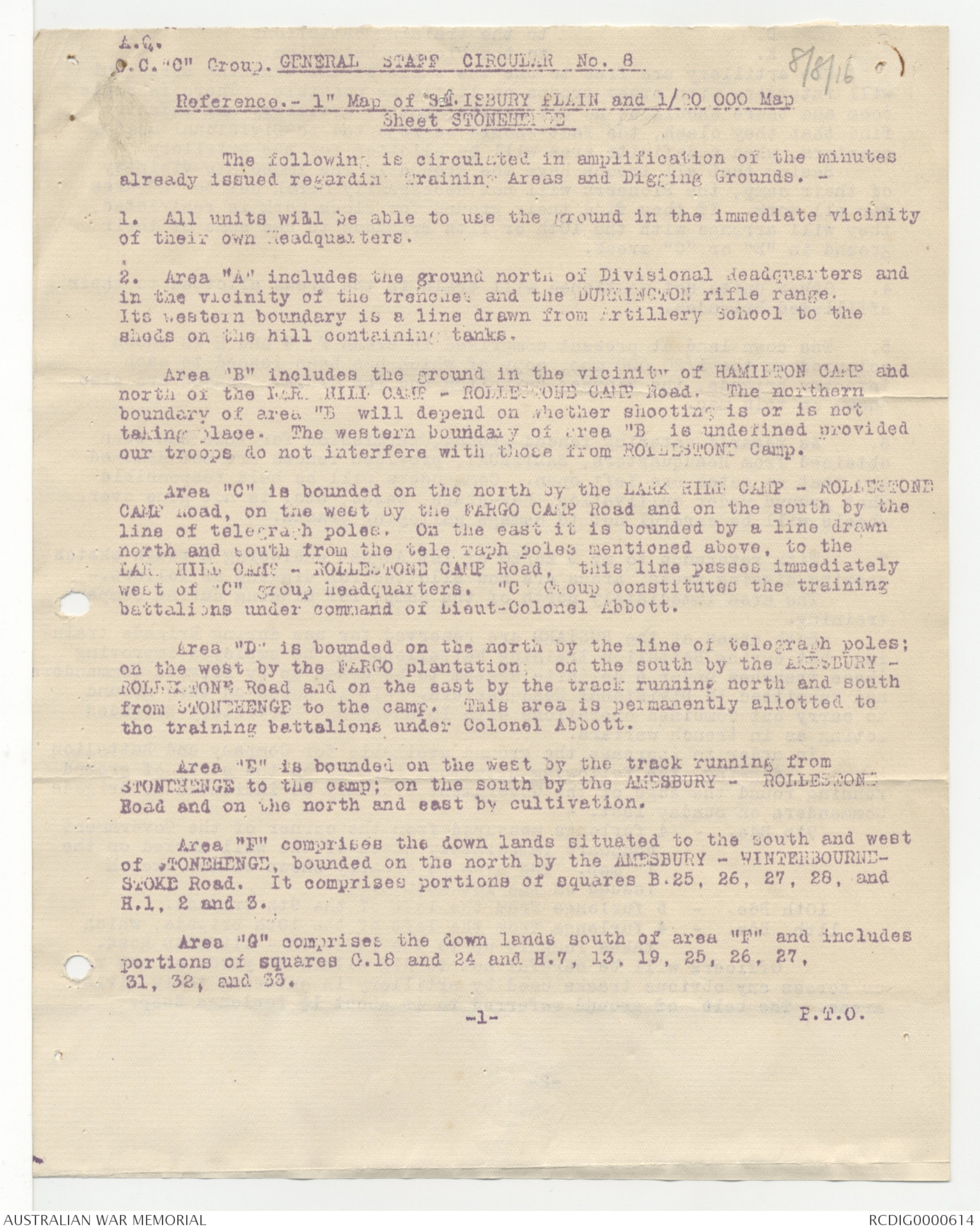
A.G.
O.C. "C" Group.
GENERAL STAFF CIRCULAR No. 8
8/8/16
Reference.- 1" Map of SALISBURY PLAIN and 1/20 000 Map
Sheet STONEHENGE
The following is circulated in amplification of the minutes
already issued regarding Training Areas and Digging Grounds. -
1. All units will be able to use the ground in the immediate vicinity
of their own Headquarters.
2. Area "A" includes the ground north of Divisional Headquarters and
in the vicinity of the trenches and the DURRINGTON rifle range.
Its western boundary is a line drawn from Artillery School to the
sheds on the hill containing tanks.
Area "B" includes the ground in the vicinity of HAMILTON CAMP and
north or the LARK HILL CAMP - ROLLESTONE CAMP Road. The northern
boundary of area "B will depend on whether shooting is or is not
taking place. The western boundary area "B is undefined provided
our troops do not interfere with those from ROLLESTONE Camp.
Area "C" is bounded on the north by the LARK HILL CAMP - ROLLESTONE
CAMP Road, on the west by the FARGO CAMP Road and on the south by the
line of telegraph poles. On the east it is bounded by a line drawn
north and south from the telegraph poles mentioned above, to the
LARK HILL CAMP - ROLLESTONE CAMP Road, this line passes immediately
west of "C” group headquarters. "C" Group constitutes the training
battalions under command of Lieut-Colonel Abbott.
Area "D' is bounded on the north by the line of telegraph poles:
on the west by the FARGO plantation; on the south by the AMESBURY -
ROLLESTONE Road and on the east by the track running north and south
from STONEHENGE to the camp. This area is permanently allotted to
the training battalions under Colonel Abbott.
Area "E" is bounded on the west by the track running from
STONEHENGE to the camp; on the south by the AMESBURY - ROLLESTONE
Road and on the north and east by cultivation.
Area "F" comprises the down lands situated to the south and west
of STONEHENGE, bounded on the north by the AMESBURY - WINTERBOURNE- STOKE Road. It comprises portions of squares B.25, 26, 27, 28, and H.1, 2 and 3.
Area "G" comprises the down lands south of area "F" and includes
portions of squares G.18 and 24 and H.7, 13, 19, 25, 26, 27.
31, 32, and 33.
-1- P.T.O.
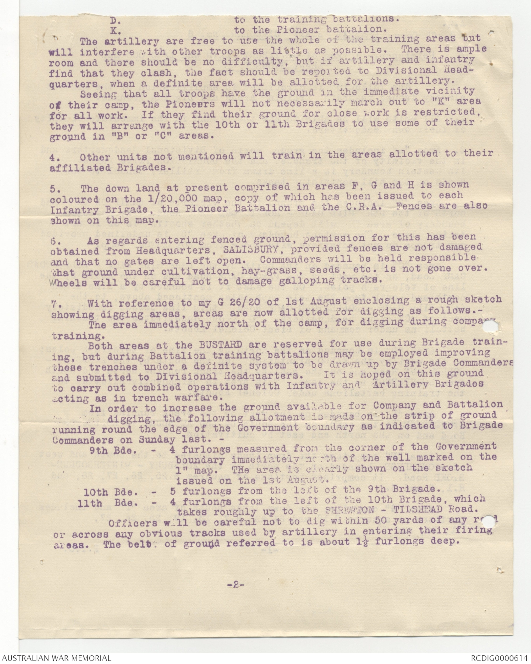
D. to the training battalions.
K. to the Pioneer battalion.
The artillery are free to use the whole of the training areas but
will interfere with other troops as little as possible. There is ample
room and there should be no difficulty, but if artillery and infantry
find that they clash, the fact should be reported to Divisional Headquarters,
when a definite area will be allotted for the artillery.
Seeing that all troops have the ground in the immediate vicinity
of their camp, the Pioneers will not necessarily march out to "K" area
for all work. If they find their ground for close work is restricted,
they will arrange with the 10th or 11th Brigades to use some of their
ground in "B" or "C" areas.
4. Other units not mentioned will train in the areas allotted to their
affiliated Brigades.
5. The down land at present comprised in areas F, G and H is shown
coloured on the 1/20,000 map, copy of which has been issued to each
Infantry Brigade, the Pioneer Battalion and the C.R.A. Fences are also
shown on this map.
6. As regards entering fenced ground, permission for this has been
obtained from Headquarters, SALISBURY, provided fences are not damaged
and that no gates are left open. Commanders will be held responsible
that ground under cultivation, hay-grass, seeds, etc. is not gone over.
Wheels will be careful not to damage galloping tracks.
7. With reference to my G 26/20 of lst August enclosing a rough sketch
showing digging areas, areas are now allotted for digging as follows.-
The area immediately north of the camp, for digging during company
training.
Both areas at the BUSTARD are reserved for use during Brigade training,
but during Battalion training battalions may be employed improving
these trenches under a definite system to be drawn up by Brigade Commanders and submitted to Divisional Headquarters. It is hoped on this ground to
carry out combined operations with Infantry and Artillery Brigades
acting as in trench warfare.
In order to increase the ground available for Company and Battalion
digging, the following allotment is made on the strip of ground
running round the edge of the Government boundary as indicated to Brigade
Commanders on Sunday last. -
9th Bde. - 4 furlongs measured from the corner of the Government
boundary immediately north of the well marked on the
1" map. The area is clearly shown on the sketch
issued on the 1st August.
10th Bde.- 5 furlongs from the left of the 9th Brigade.
11th Bde. - 4 furlongs from the left of the 10th Brigade, which
takes roughly up to the SHREWTON - TILSHEAD Road.
Officers will be careful not to dig within 50 yards of any road
or across any obvious tracks used by artillery in entering their firing
areas. The belt of ground referred to is about 1½ furlongs deep.
-2-
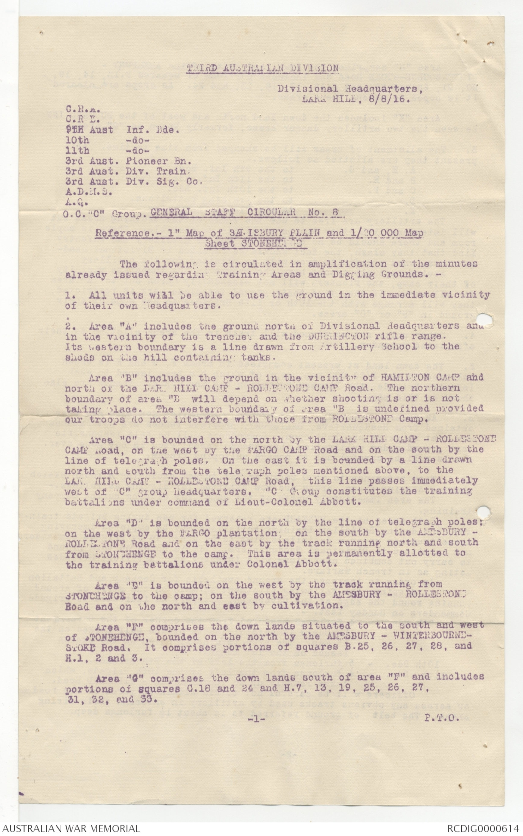
THIRD AUSTRALIAN DIVISION
Divisional Headquarters,
LARK HILL, 8/8/16.
C.R.A.
C.R.E.
9th Aust Inf. Bde.
10th -do-
11th -do-
3rd Aust. Pioneer Bn.
3rd Aust. Div. Train.
3rd Aust. Div. Sig. Co.
A.D.M.S.
A.G.
O.C. "C" Group. GENERAL STAFF CIRCULAR No .8
Reference.- 1" Map of SALISBURY PLAIN and 1/20 000 Map
Sheet STONEHENGE
The following is circulated in amplification of the minutes
already issued regarding Training Areas and Digging Grounds. -
1. All units will be able to use the ground in the immediate vicinity
of their own Headquarters.
2. Area "A" includes the ground north of Divisional Headquarters and
in the vicinity of the trenches and the DURRINGTON rifle range.
Its western boundary is a line drawn from Artillery School to the
sheds on the hill containing tanks.
Area "B" includes the ground in the vicinity of HAMILTON CAMP and
north of the LARK HILL CAMP - ROLLESTONE CAMP Road. The northern
boundary of area "D" will depend on whether shooting is or is not
taking place. The western boundary of area "B" is undefined provided
our troops do not interfere with those from ROLLESTONE Camp.
Area "C" is bounded on the north by the LARK HILL CAMP - ROLLLESTONE
CAMP road, on the west by the FARGO CAMP Road and on the south by the
line of telegraph poles. On the east it is bounded by a line drawn
north and south from the telegraph poles mentioned above, to the
LARK HILL CAMP - ROLLESTONE CAMP Road, this line passes immediately
west of "C” group headquarters. "C" Group constitutes the training
battalions under command of Lieut-Colonel Abbott.
Area "D" is bounded on the north by the line of telegraph poles;
on the west by the FARGO plantation; on the south by the AMESBURY -
ROLLESTONE Road and on the east by the track running north and south
from STONEHENGE to the camp. This area is permanently allotted to
the training battalions under Colonel Abbott.
Area "E" is bounded on the west by the track running from
STONEHENGE to the camp; on the south by the AMESBURY - ROLLESTONE
Road and on the north and east by cultivation.
Area "F" comprises the down lands situated to to the south and west
of STONEHENGE, bounded on the north by the AMESBURY - WINTERBOURNE -STOKE Road. It comprises portions of squares B.25, 26, 27, 28, and H.1, 2 and 3.
Area "G" comprises the down lands south of area "F" and includes
portions of squares G.18 and 24 and H.7, 13, 19, 25, 26, 27.
31, 32, and 33.
-1- P.T.0.
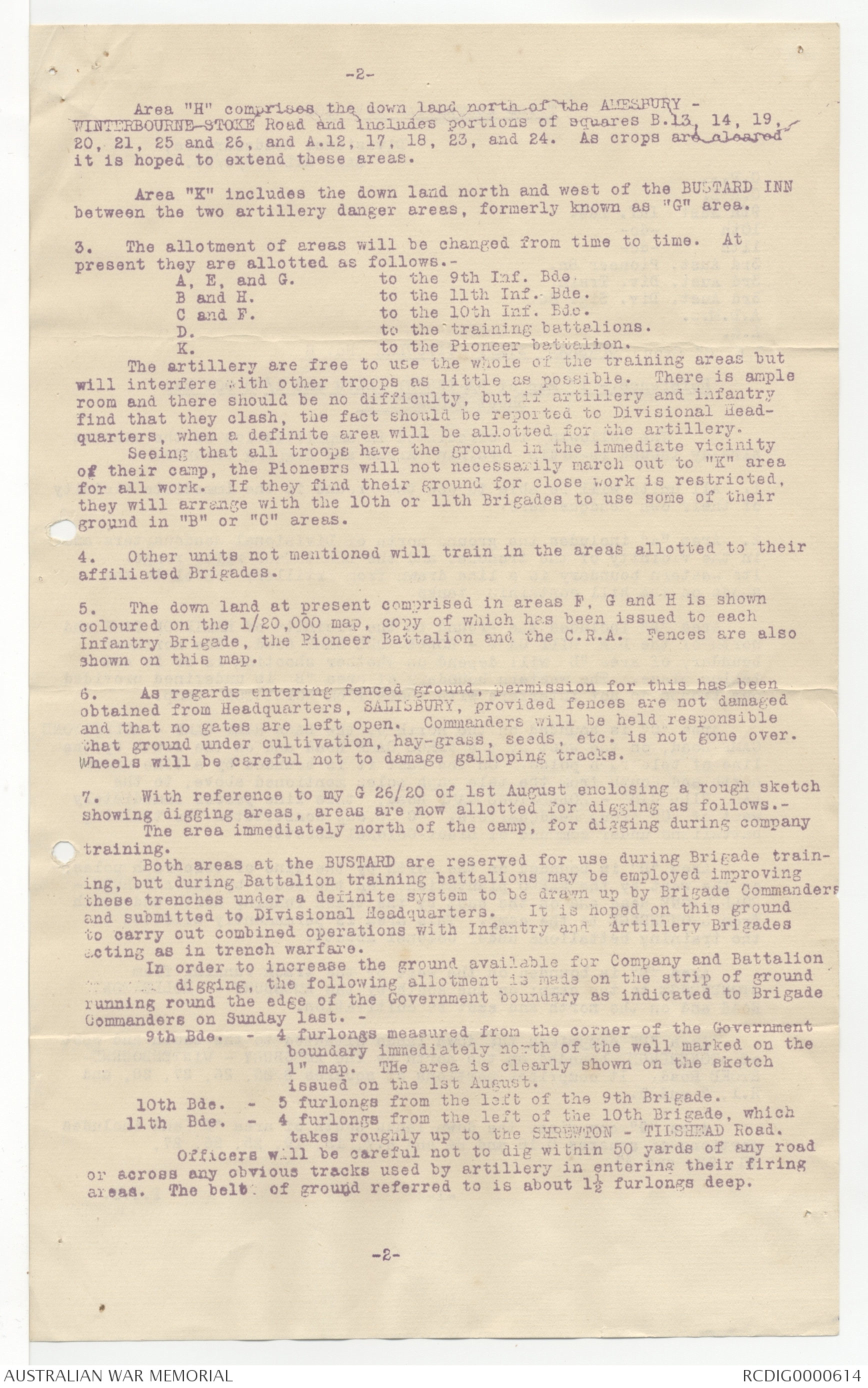
-2-
Area "H" comprises the down land north of the AMESBURY -
WINTERBOURNE-STOKE Road and includes portions of squares B.13, 14, 19,
20, 21, 25 and 26, and A.12, 17, 18, 23, and 24. As crops are cleared
it is hoped to extend these areas.
Area "K" includes the down land north and west of the BUSTARD INN
between the two artillery danger areas, formerly known as "G" area.
3. The allotment of areas will be changed from time to time. At
present they are allotted as follows.-
A, E, and G. to the 9th Inf. Bde.
B and H. to the 11th Inf. Bde.
C and F. to the 10th Inf. Bde.
D. to the training battalions.
K. to the Pioneer battalion.
The artillery are free to use the whole of the training areas but
will interfere with other troops as little as possible. There is ample
room and there should be no difficulty, but if artillery and infantry
find that they clash, the fact should be reported to Divisional Headquarters,
when a definite area will be allotted for the artillery.
Seeing that all troops have the ground in the immediate vicinity
of their camp, the Pioneers will not necessarily march out to "K" area
for all work. If they find their ground for close work is restricted,
they will arrange with the 10th or 11th Brigades to use some of their
ground in "B" or "C" areas.
4. Other units not mentioned will train in the areas allotted to their
affiliated Brigades.
5. The down land at present comprised in areas F, G and H is shown
coloured on the 1/20,000 map, copy of which has been issued to each
Infantry Brigade, the Pioneer Battalion and the C.R.A. Fences are also
shown on this map.
6. As regards entering fenced ground, permission for this has been
obtained from Headquarters, SALISBURY, provided fences are not damaged
and that no gates are left open. Commanders will be held responsible
that ground under cultivation, hay-grass, seeds, etc. is not gone over.
Wheels will be careful not to damage galloping tracks.
7. With reference to my G 26/20 of lst August enclosing a rough sketch
showing digging areas, areas are now allotted for digging as follows.-
The area immediately north of the camp, for digging during company
training.
Both areas at the BUSTARD are reserved for use during Brigade training,
but during Battalion training battalions may be employed improving
these trenches under a definite system to be drawn up by Brigade Commanders and submitted to Divisional Headquarters. It is hoped on this ground
to carry out combined operations with Infantry and Artillery Brigades
acting as in trench warfare.
In order to increase the ground available for Company and Battalion
digging, the following allotment is made on the strip of ground
running round the edge of the Government boundary as indicated to Brigade
Commanders on Sunday last. -
9th Bde.- 4 furlongs measured from the corner of the Government
boundary immediately north of the well marked on the
1" map. THe area is clearly shown on the sketch
issued on the 1st August.
10th Bde.- 5 furlongs from the left of the 9th Brigade.
11th Bde - 4 furlongs from the left of the 10th Brigade, which
takes roughly up to the SHREWTON - TILSHEAD Road.
Officers will be careful not to dig within 50 yards of any road
or across any obvious tracks used by artillery in entering their firing
areas. The belt of ground referred to is about 1½ furlongs deep.
-2-
-3-
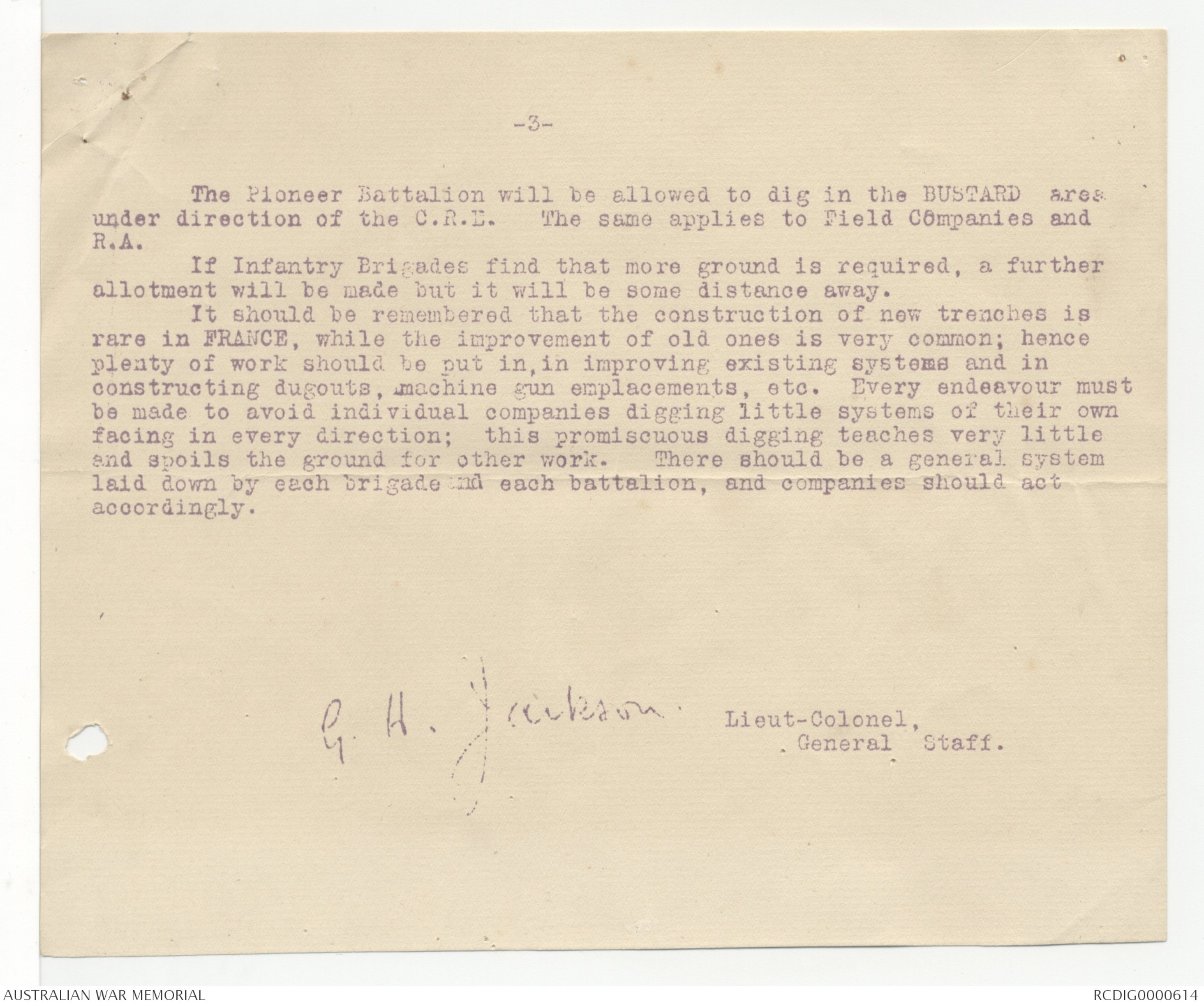
The Pioneer Battalion will be allowed to dig in the BUSTARD area
under direction of the C.R.E. The same applies to Field Companies and
R.A.
If Infantry Brigades find that more ground is required, a further
allotment will be made but it will be some distance away.
It should be remembered that the construction of new trenches is
rare in FRANCE, while the improvement of old ones is very common; hence
plenty of work should be put in, in improving existing systems and in
constructing dugouts, machine gun emplacements, etc. Every endeavour must
be made to avoid individual companies digging little systems of their own
facing in every direction; this promiscuous digging teaches very little
and spoils the ground for other work. There should be a general system
laid down by each brigade and each battalion, and companies should act
accordingly.
G.H. Jackson
Lieut-Colonel
General Staff.
GOC wishes
you to read
note & return
this please.
GH.
 Transcriber 8364
This transcription item is now locked to you for editing. To release the lock either Save your changes or Cancel.
This lock will be automatically released after 60 minutes of inactivity.