Charles E W Bean, Diaries, AWM38 3DRL 606/232/1 - Folder - Part 8
36.
3/3/1919. Back via 971 (overlooking Anafarta).
In a gully at the north of Koja Dere was lying the
body of our old 4.7 gun - Hughes had located it before.
Raced home in a snow storm.
March 4th. Wilkins ill with ptomaine poisoning - insisted on
going out before lunch as the day was very fine though
Tuesday. very cold.
I went with Buchanan to Hill 60 to place the exact
point reached by the attack of 4th Bde. of Aug. 8th.
They themselves have never been certain of it. We went
up Asma Dere and left the horses in the first gully on
the left, out of the wind. Then we climbed the opposite
height a little S of Hill 90 - and on Hill 90, almost at
once, we found a cluster of Australians lying dead. The
slope shelved up slightly towards the hill on which Zeki
Bey had told us the 11th Regt.'s M.G. Coy. had its guns -
and was about 600 yards away - just a beautiful M.G.
range. The men lay in a bunch as if the M.G. had got
onto the head of the column. There were 14th Bn. badges
on two of the men; there were several groups about. One
man had a bible - on it was written "J "H. WELLINGTON".
We could find none on the N slope of the hill nor in
the Asma Dere. After lunch we searched the slopes north
of the Asma Dere. Immediately north of the lower slopes
of the Hill 60 spur (i.e. the spur from Hill 100 to Hill
60) there had been a Turkish firing line. One man must
have fired 200 rounds. Clearly he was firing at some
attack coming over that hill - he couldn't see our troops
in any attack except that day's attack.
We crossed the gully and on the low scrubby end of
the ridge, about 700 yards NE of Hill 100 (I should say)
found another group of our men who had been buried by the
Turks and dug up later by someone. We could find no Bn.
badges. There were odd men scattered about all through
the scrub - not enough to account for the day's losses.
These can only be accounted for by the Turk having buried
them.
From between the left and right of the line we
identified I made sketch B A, showin gxx the position
from which the M.G.'s fired on them. The left of the
attack had passed a big cornfield, on the slope exposed to
the enemy. Beyond it were one or two smaller open spaces.
On the reverse (N) slope of the hill were several dead
Turks, whether killed in this counterattack I don't know.
We went back by the Turkish M.G. position from which
I made sketch B B. The attack had been evidently made
up the slope between Kaiajik Dere and Asma Dere.
We went back by 971 in order to see if we could find
any further traces of the Ghurkas. Pretty well every
question which we came here to solve has been settled
except this one. Most of the few traces of British kit
which exist have been found just south of Q, north. We
went to this point and descended into the valley from
there. The scrub was very thick. It was scrub all the
way down. Buchanan went pretty well to the bottom and I
went a good way down - further to the left - and neither
found the least trace of any British kit. I worked to
the left about half-way down the hill; and on rounding
the shoulder of Q found a ledge on the lower end of
which was a trench. Part of this trench was old and
seemed to have been used by us as it had little dugouts
on the Turkish side. On the right of it was a shoulder
up which the trench ran. The Turks had built several
trenches on this ledge also. I went up the hill from
37.
4/3/1919. there - found one bit of British kit near the trench.
The slope was by no means impossible.
xxx Diagram - see original document.
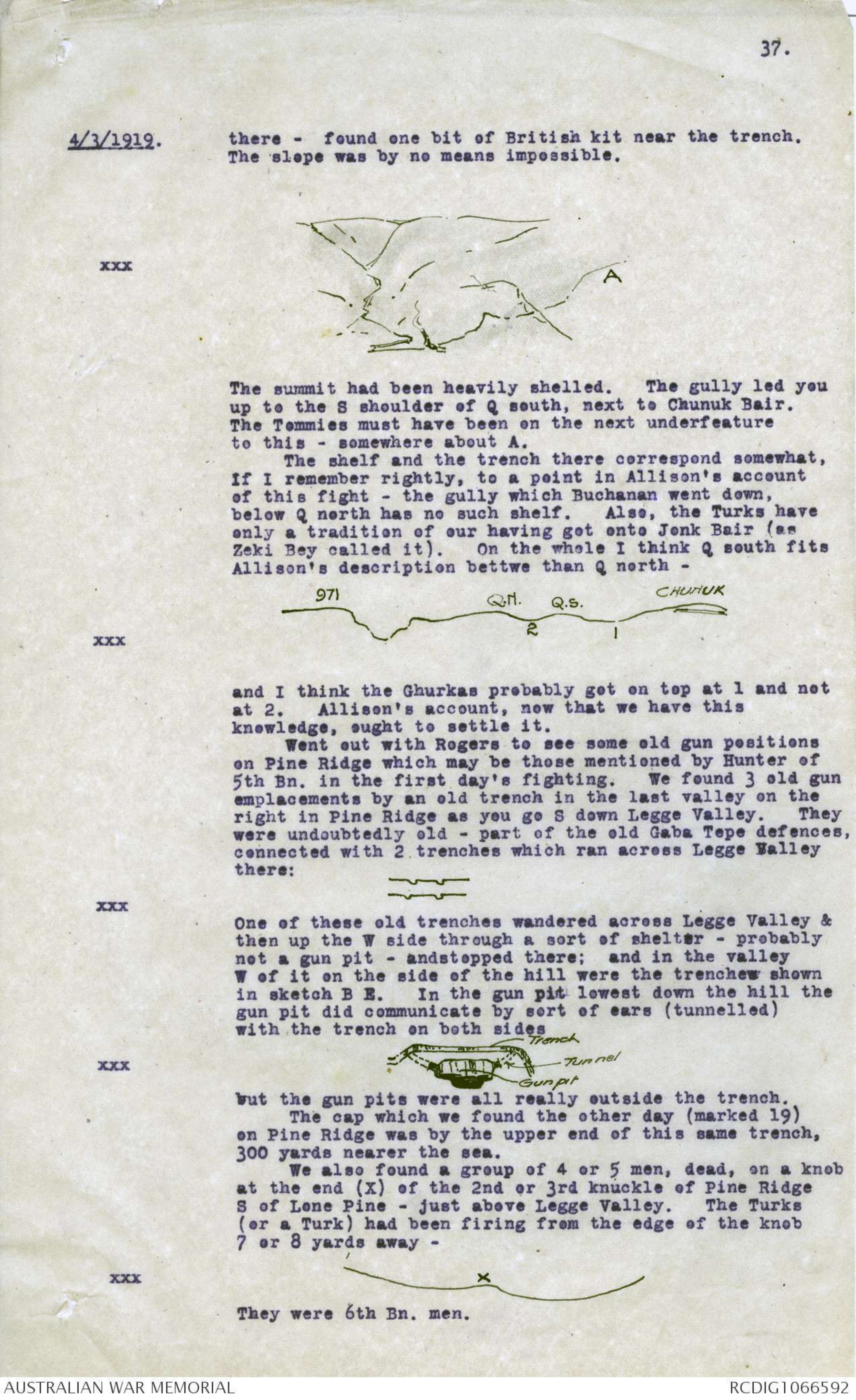
The summit had been heavily shelled. The gully led you
up to the S shoulder of Q south, next to Chunuk Bair.
The Tommies must have been on the next underfeature
to this - somewhere about A.
The shelf and the trench there correspond somewhat,
if I remember rightly, to a point in Allison's account
of this fight - the gully which Buchanan went down,
below Q north has no such shelf. Also, the Turks have
only a tradition of our having got onto Jenk Bair (as
Zeki Bey called it). On the whole I think Q south fits
Allison's description bettwe than Q north -
xxx Diagram - see original document
and I think the Ghurkas probably got on top at 1 and not
at 2. Allison's account, now that we have this
knowledge, ought to settle it.
Went out with Rogers to see some old gun positions
on Pine Ridge which may be those mentioned by Hunter of
5th Bn. in the first day's fighting. We found 3 old gun
emplacements by an old trench in the last valley on the
right in Pine Ridge as you go S down Legge Valley. They
were undoubtedly old - part of the old Gaba Tepe defences,
connected with 2 trenches which ran across Legge Valley
there:
xxx Diagram - see original document
One of these old trenches wandered across Legge Valley &
then up the W side through a sort of shelter - probably
not a gun pit - and stopped there; and in the valley
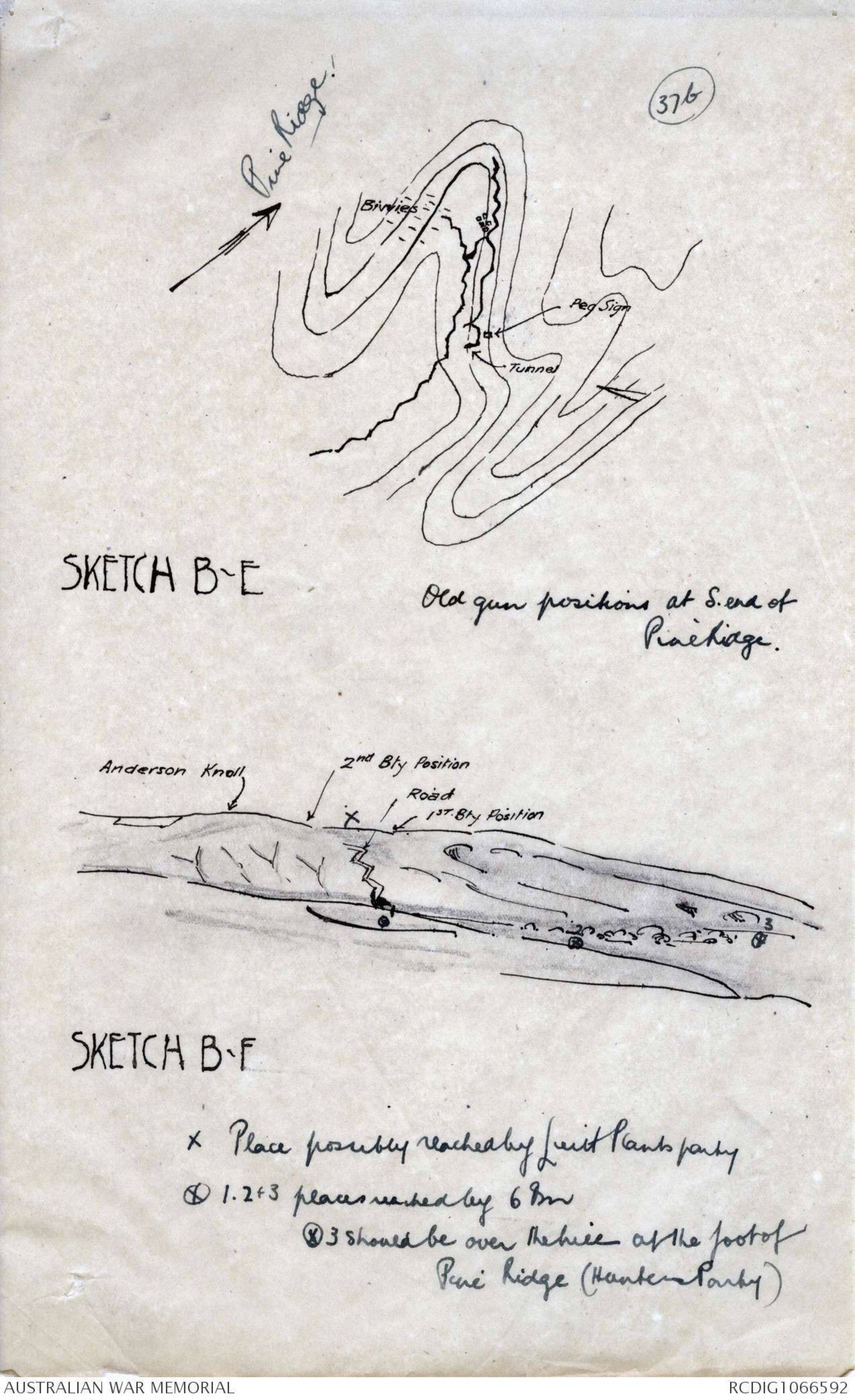
W of it on the side of the hill were the trenchew shown
in sketch B E. In the gun pit lowest down the hill the
gun pit did communicate by sort of ears (tunnelled)
with the trench on both sides
xxx Diagram - see original document
but the gun pits were all really outside the trench.
The cap which we found the other day (marked 19)
on Pine Ridge was by the upper end of this same trench,
300 yards nearer the sea.
We also found a group of 4 or 5 men, dead, on a knob
at the end (X) of the 2nd or 3rd knuckle of Pine Ridge
S of Lone Pine - just above Legge Valley. The Turks
(or a Turk) had been firing from the edge of the knob
7 or 8 yards away -
xxx Diagram - see original document
They were 6th Bn. men.
Diagram - see original document
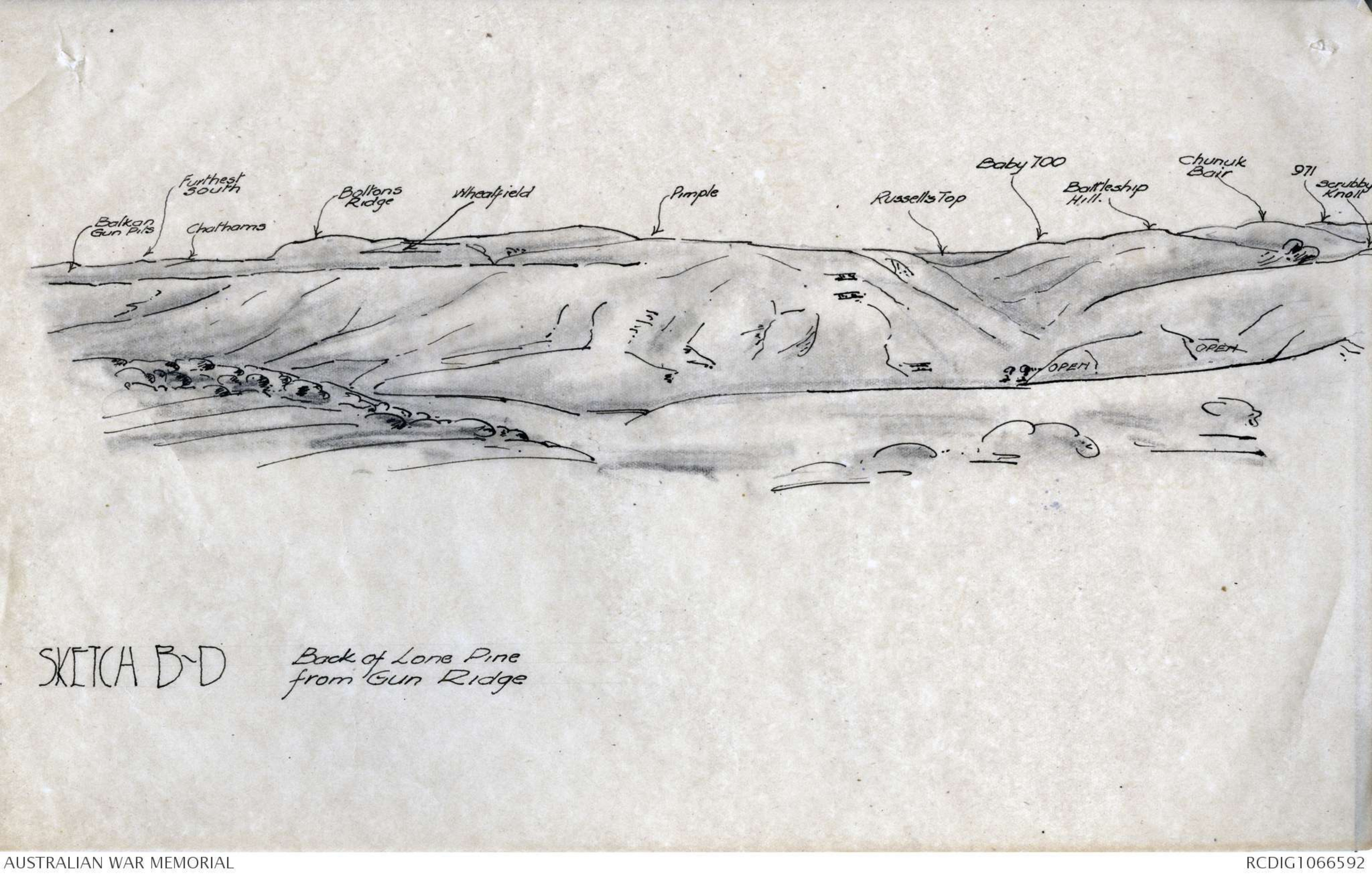
SKETCH B-G
Back of Lone Pine
from Gun Ridge
Diagram - see original document
SKETCH B-E
Old gun positions at S.end of
PineRidge.
Diagram - see original document
SKETCH B-F
38.
4 5/3/1919.
On my way back I made a sketch of Leane's trench
from Sniper’s Ridge - to show the washaways. They are
not so precipitous as one had expected. North of the
wheatfield there is a tremendous collection of bones in
a similar washaway - probably men killed by Rosenthal’s
guns in the wheatfield in he first few days. The
washaway is white with them.
I found the men, probably, of 9th Bn. who were
killed on June 28th. just outside the trenches on Snipers
Ridge north of the Knife Edge, about 20 yards north of
the Nek between the two (Peg 32 here).
In the afternoon I went S along gun Ridge from
Anderson's Knoll, to see if I could find traces of
Plant's party. Plant, of 9th Bn., says he went till they
were looking over open country - "a hell of a distance" -
but could not be sure that there was any part of the
Dardanelles seen from there. Balfour found one of our
fired cartridges on Gun Ridge opposite the foot og Pine
Ridge and a little beyond (S of) it, the other day.
Anywhere from about 50 yards S of Anderson knoll for
500 or 600 yards a man not quite getting over the skyline
would have this view (i.e., open country but not
Dardanelles water); and on the S shoulder of the knoll
he cannot see the Dardanelles even when he is on the
crest. You cannot see over green fields anywhere except
from this section of Gun Ridge. I think Plant said he
was looking towards Kilid Bahr.
As Gun Ridge (see sketch B D) thereis only 700 yds.
from the point which Hunter (who landed much later)
probably reached, it is probable that Plant and a party
of 9th Bn. did reach hhis part of Gun Ridge before being
pushed back. Several clips of cartridges had been fired
by Turks near the top of the ridge (on the Maidos xxx//
SE side of it) near the guns south of Anderson Knoll.
They may have been ffired at someone wither a little S
of the knoll, or 600 or 700 yards S of it.
I found two lots of gun positions - one at the head
of the valley S Anderson's Knoll (the firing was near
there); the other at the head of the next valey further
S. near point 87. These had been built to fire towards
Gabe Tepe, I fancy, and afterwards swung round towards
Bolton’s Hill. Both were near the Gaba Tepe road on
the hill top.
March 6th. Went with Wilkins to Essad's H.Q. in morning.
Returned via ridge behind our camp, which I think Lentit's
party reached. They would have to be within 250-300
yards of Scrubby Knoll to see the Dardanelles. The
furthest traces we found were about 600-700 yards South
of Scrubby Knoll. Marked all these positions.
Went via Pine to Anzac Beach in afternoon. Found
our kit and cartridges right on edge of plateau above
Turkish Bn. H.Q. where Zeki Bey says they reached.
Marked spot where Bridges was hit, Bridge's H.Q.,
Birdwood’s, Walker's and White's H.Q., for Hughes.
The timbers of Lone Pine have been all used by
Turks in making huts behind their lines (in Legge Valley}
after the evacuation. We found in a hut timber scribbled
on by our garrison in the Pine.
March 7th.
Party consisting of Lambert, Wilkins, Buchanan and
myself, with groom and orderly, rode down to Seddelbahr.
Balfour stayed to bring over the camp and trophies which
Lieut. James will bring to Australia
Captain Bigg Wether and Lieut. Highes, N.Z. and
Australian officers on the Graves Registration Union,
came down too.
39.
7/3/1919. From Kilid Bahr we followed the tram line along
the coast to Seghum Fere; and then inland up the Dere
for ¼ mile; then up a very steep waggon road winding over
the hillside to the left (S) side of Seghum Dere.
This brought us out on a plateau which would have
had to be won even if the British had taken Achi Baba.
The Turks had had reserves camped in the xxx Dere. There
were a big shellhole or two in it from the shells of the
ships' guns. Even this would not have solved the
problem of the Narrows - the Kilid Bahr plateau would
still protect the forts from observation. Indeed it is
clear that Hill 971 at Anzac commanded the Narrows far
more than Achi Baba.
From the summit of the crest south of Seghum Dere
we went down into another deep valley, and then up over
a hill which proved the SE shoulder of the Achi Baba
highland. There the trenches began, one of the roads
having been sunk about 4 ft. on the summit, and the
forward part of the crest was pretty constantly shellholed;
about as much as a gun position in a pretty quiet part
of the line in France. There were 4 big gun positions j
just on the left of our road.
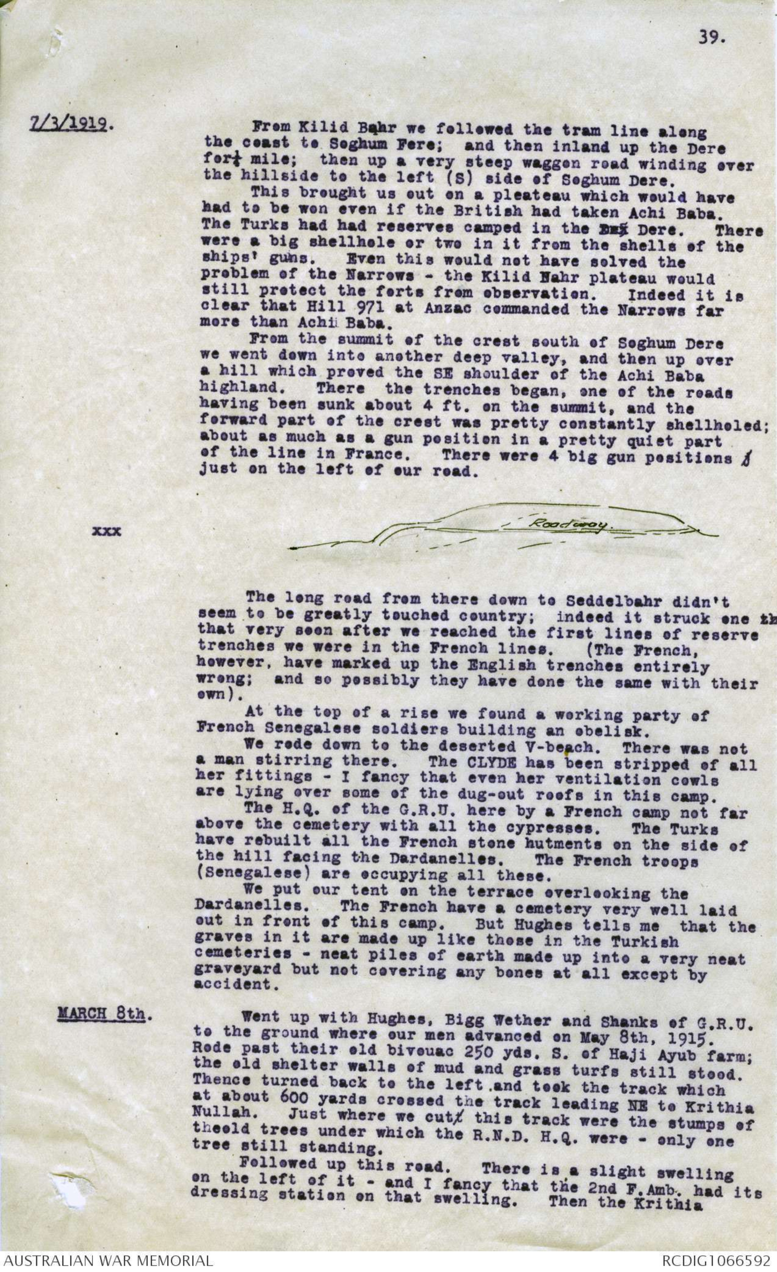
xxx Diagram - see original document
The long road from there down to Seddelbahr didn't
seem to be greatly touched country; indeed it struck one th
that very soon after we reached the first lines of reserve
trenches we were in the French lines. (The French,
however, have marked up the English trenches entirely
wrong; and so possibly they have done the same with their
own).
At the top of a rise we found a working party of
French Senegalese soldiers building an obelisk.
We rode down to the deserted V-beach. There was not
a man stirring there. The CLYDE has been stripped of all
her fittings - I fancy that even her ventilation cowls
are lying over some of the dug-out roofs in this camp.
The H.Q. of the G.R.U. here by a French camp not far
above the cemetery with all the cypresses. The Turks
have rebuilt all the French stone hutments on the side of
the hill facing the Dardanelles. The French troops
(Senegalese) are occupying all these.
We put our tent on the terrace overlooking the
Dardanelles. The French have a cemetery very well laid
out in front of this camp. But Hughes tells me that the
graves in it are made up like those in the Turkish
cemeteries - neat piles of earth made up into a very neat
graveyard but not covering any bones at all except by
accident.
MARCH 8th. Went up with Hughes, Bigg Wether and Shanks of G.R.U.
to the ground where our men advanced on May 8th, 1915.
Rode past their old bivouac 250 yds. S. of Haji Ayub farm;
the old shelter walls of mud and grass turfs still stood.
Thence turned back to the left, and took the track which
at about 600 yards crossed the track leading NE to Krithia
Nullah. Just where we cutt this track were the stumps of
theold trees under which the R.N.D. H.Q. were - only one
tree still standing.
Followed up this road. There is a slight swelling
on the left of it - and I fancy that the 2nd F.Amb. had its
dressing station on that swelling. Then the Krithia
Diagram - see original document
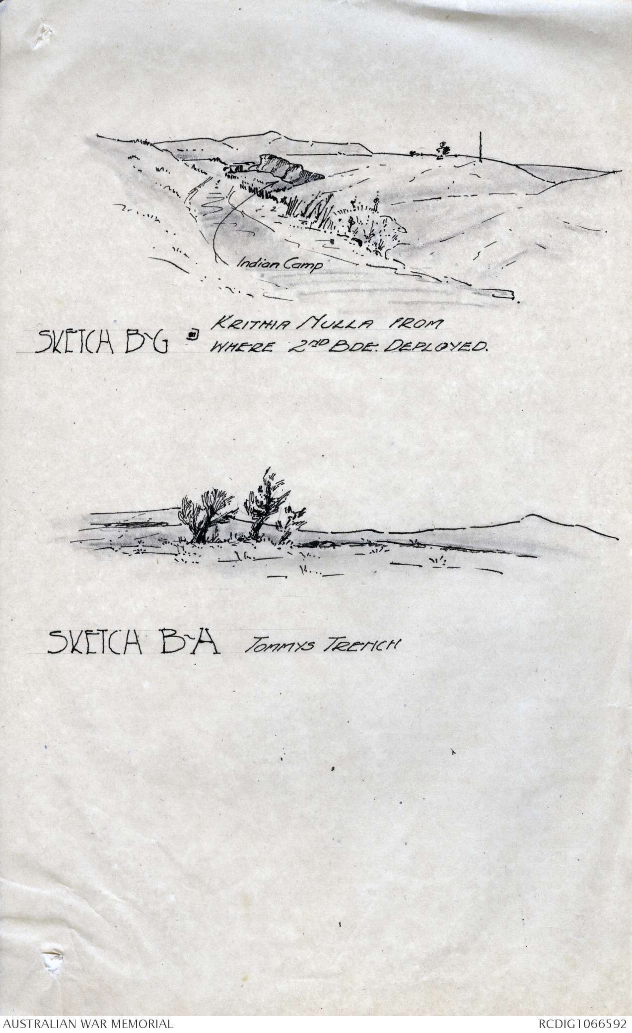
SKETCH B-G KRITHIA NULLA FROM
WHERE 2ND BDE: DEPLOYED.
Diagram - see original document
SKETCH B-A TOMMYS TRENCH
40.
8/3/1919. stream comes towards the road and begins to have steep
banks of its own. It is where these banks become about
8 or 10 ft. high that there xxxxxxx was a hollow in them
in which Capt McG ∧Mathieson medical officer of 5th Bn., had
his little dressing station for walking (or was it
serious?) cases - and where he was killed in the morning
while putting on his socks after refreshing himself with
a wash after 24 hours' heavy work.
Old 2nd Bde. H.Q. was not easy to spot, but we got
to within 50 yards or so - Buchanan marked it. It was
in the E bank just where it begins to widen out to the
spoonshaped depression on the right (E) of the stream;
where the 2nd Bde, deployed. Just where this depression
runs into it there is a fork in the stream; and on the
bank or island in the middle of the fork the Indian
troops were camped when we reached there on May 8, 1915.
This Buchanan marked on the map and xxxxxxxx Wilkins
photographed.
From near here I drew sketch B G. It can be read
with the diary of my 2nd visit to Cape Helles (with
Blamey and M'Cay), being more accurate than the sketches
there, which were from memory.
The party cut off half-right up the xxx gentle slope
shown in this sketch (just as M'Cay's Bde. H.Q. had done).
On the top of that rise we first came to two or three
lines of trench and irregular dugout riflepits - the
third being the most important. This was deeper than
the trenches into which I remember stumbling at the time
of the attack - and I think it is the Eski Line. From
there a long way over the open - without xxx shelter of
any sort - only the xxx low rounded grey-blue and green
shrubs like saltbush with the dry, light pinky earth
between them - and we came to the "Tommy's Trench".
I could pick up at once the three or four wild olive trees
which grew over the Tommy's trench. As a matter of
fact one of them - a skinny one, grows on the parados of
the trench; and two out ahead of it - tandem; and one
further behind it. This last is in a slightly raised line
of bushes along some forgotten border of a field - or
hedge or road. This I remember very well - it was just
on our left. The ground to the immediate right of it is
open and almost clear of vegetation; it has been
cultivated.
The Tommies' trench has not greatly changed. It is
almost exactly as it was - with a meaningless collection
of holes behind it. Many of these have been filled in
since by burying our men in them; others lie in the
hedge-like row of tufted scrub on the left - at least
two lots. Here I made drawing B H showing this line of
scrub leading up to Tommies' trench.
From the Tommies' trench we went on following more or
less the track I had taken. There were many Australian
dead lying all over this area. Two C.T.'s start a little
E of the olive trees and run forward, separating a bit
till they reach the line of the Australians (redoubt and
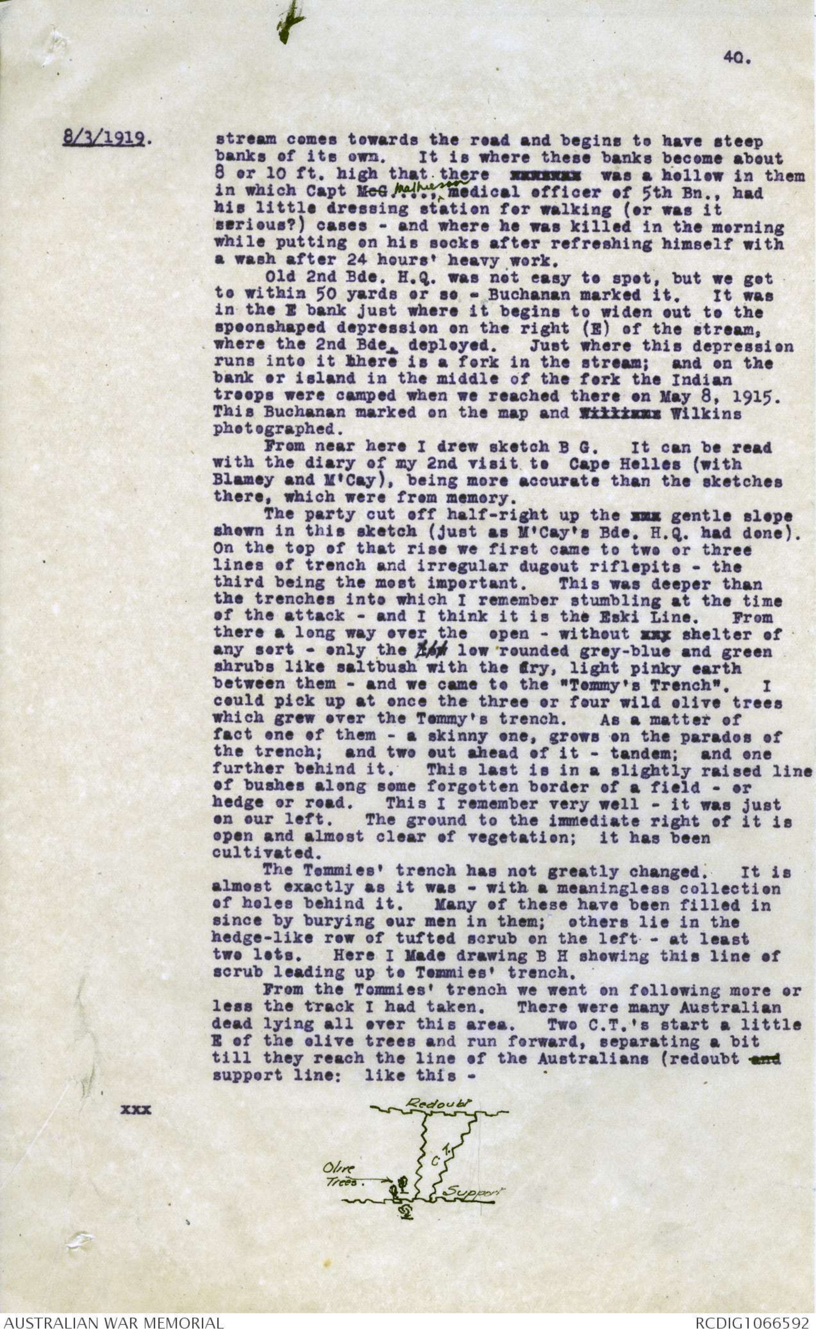
support line; like this -
xxx Diagram - see original document
41.
8/3/1919. These were later work, of course. 100 yards ahead of
the redoubt support line is another line (redoubt line),
which I was uncertain about. I was rather of the opinion
that this might have been the work of Tommies digging
forward from the line we reached. We examined Nomansland
in between these two lines, working with an interval
between us. We picked up a fair amount of Australian
kit, but I was not quite convinced till Hughes found the
sleeve and shoulder straps of one of our men with the 6th
Bn. colours and the AUSTRALIA in bronze still on them.
That of course proved it beyond question. Afterwards I
followed the line down to the bed of the Krithia nullah
where it joined the N.Z. line. We found the old Bde,
H.Q. a little behind the support line, with two men
buried in the parapet. One of them, poor chap, would be
the man wo whom I gave an opium pill.
This settled the point reached by the 2nd Bde,
definitely.
After lunch I went on with Wilkins and Buchanan to
Krithia. The village had been robbed of all its
woodwork by the Turks for their trenches and is a complete
ruin. Back by the Gully ravine, which runs further north
than Krithia.
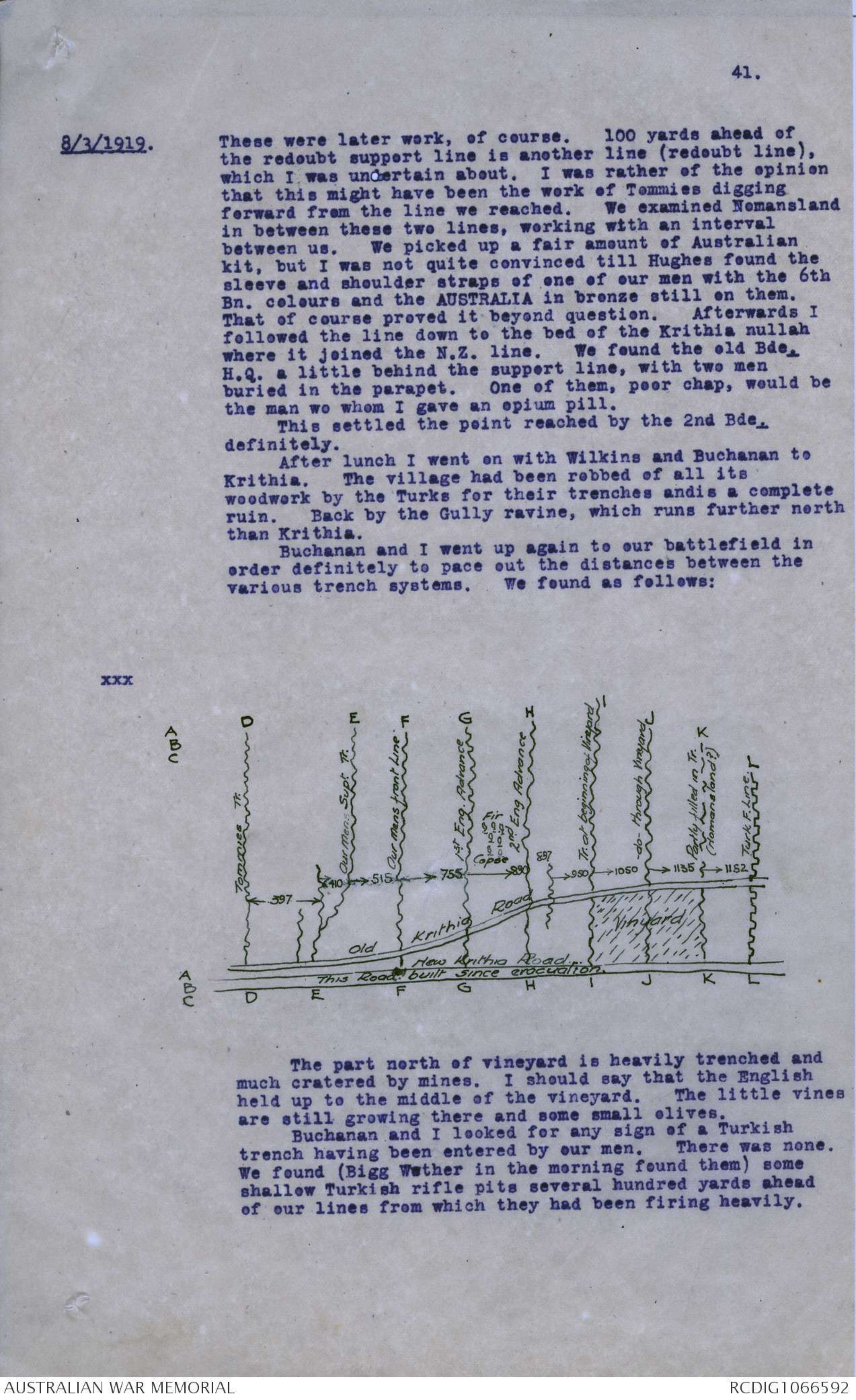
Buchanan and I went up again to our battlefield in
order definitely to pace out the distances between the
various trench systems. We found as follows:
xxx Diagram - see original document
The part north of vineyard is heavily trenched and
much cratered by mines. I should say that the English
held up to the middle of the vineyard. The little vines
are still growing there and some small olives.
Buchanan and I looked for any sign of a Turkish
trench having been entered by our men. There was none.
We found (Bigg Wether in the morning found them) some
shallow Turkish rifle pits several hundred yards ahead
of our lines from which they had been firing heavily.
42.
8/3/1919. The French had a party of Senegalese natives out
salvaging the battlefield with sacks. I don't know what
they were getting. The French have marked up along the
Gully Ravine and the Krithia road the dates on which the
various trenches were taken; but as far as I could check
them all these marks were widely wrong.
The French 45th Regt, has, for example, put up on the
Tommies' Trench (line D), which was front line up till
5.30 p.m. May 8 (and had surely not been unchanged for a
week before), "Position Anglaise du 30 Avril 1915".
The front line reached by us on May 8, 515 yards ahead
of the line held till May 8, was marked: "Position
Anglaise du 4 Mai".
The Turkish front line beyond the vineyard, which
I do not think was ever held by us - though the R.N.D.
probably passed it considerably in June - is marked:
"English position of the 21st June".
I picked up an English waterbottle and other gear
beyond this; but these trenches were never held by our
side.
The old Krithia Road, which is not now used but
which is clearly traceable, is in some places slightly
raised above the surrounding soil owing to its surface
having been hardened (as happens in our central districts
in Australia) and the surface elsewhere weathered down.
That was probably how it was that Cass noticed
bullets striking the right (E) side of the stones there.
[*Later. This is not the road - the new road X
is clearly shown by maps to have existed at date of Gallipoli campaign -
it ws probably made by Lv. Sanders' orders.*]
March 9th.
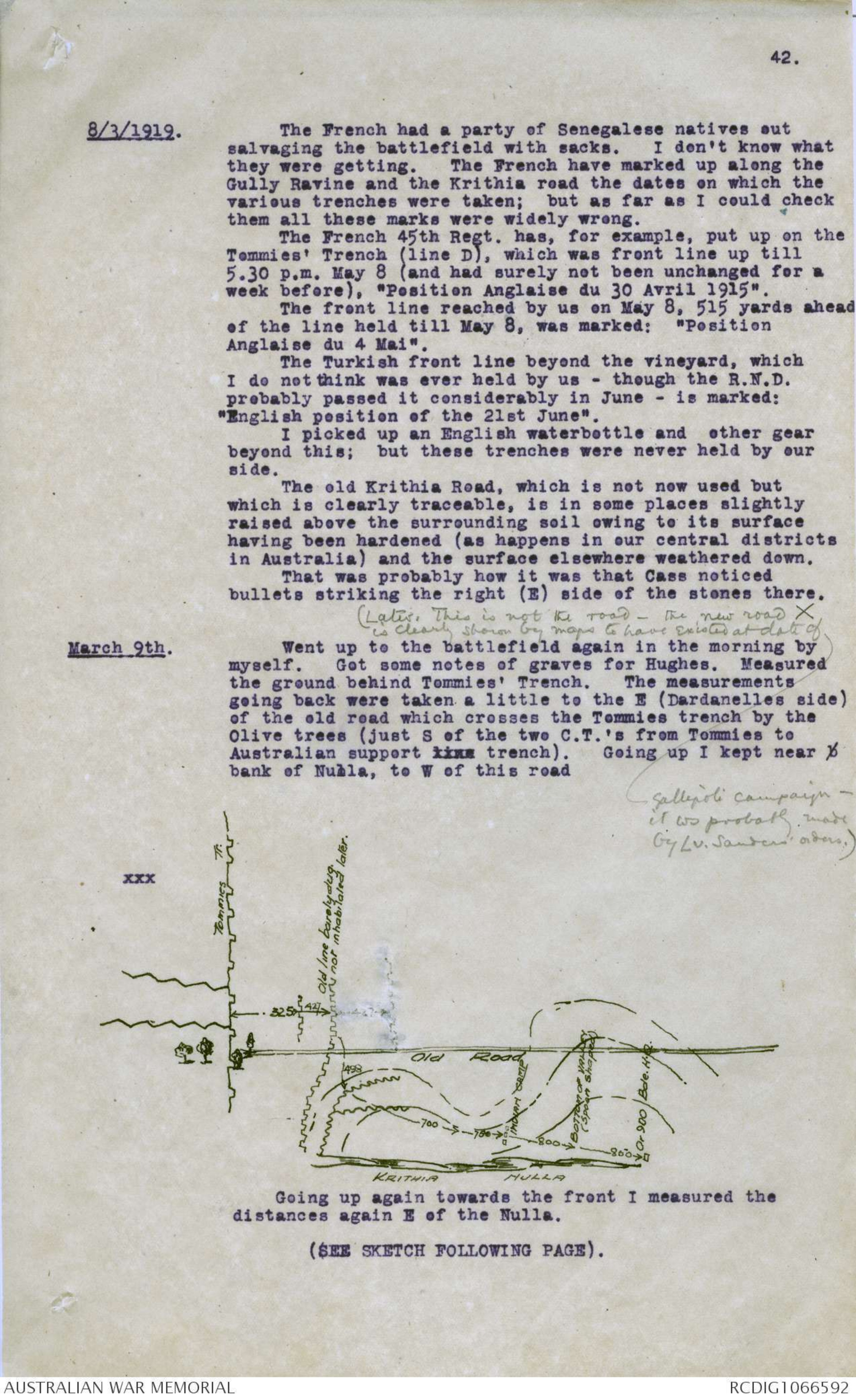
Went up to the battlefield again in the morning by
myself. Got some notes of graves for Hughes. Measured
the ground behind Tommies' Trench. The measurements
going back were taken a little to the E (Dardanelles side)
of the old road which crosses the Tommies trench by the
Olive trees (just S of the two C.T.'s from Tommies to
Australian support xx trench). Going up I kept near b
bank of Nulla, to W of this road
xxx Diagram - see original document
Going up again towards the front I measured the
distances again E of the Nulla.
(SEE SKETCH FOLLOWING PAGE).
 Deb Parkinson
This transcription item is now locked to you for editing. To release the lock either Save your changes or Cancel.
This lock will be automatically released after 60 minutes of inactivity.