General, Sir John Monash, Personal Files Book 20, 15 August - 8 September 1918 - Part 11

[*G.O.C*]
REPORT ON THE ST. QUENTIN CANAL.
SOURCES OF SUPPLY. -
This canal was built to connect the canalised river ESCAUT
with the SOMME Canal, which it joins at ST. SIMON. It then continues
south to meet the SAMBRE - OISE Canal at FARGNIER (west of
LA MERE), and the OISE - AISNE Canal south-west of CHAUNY.
In its upper reaches north of ST. QUENTIN the Canal is supplied
with water from three sources.
(a) The ESCAUT river at Le BOSQUET. North of this point
the Canal merges into the ESCAUT Canal.
(NOTE ON THE ESCAUT. - This river rises at 62B. ,
A.18.d. and flows past GOUY and LE CATELET to near VENDHUILLE
and thence north alongside the Canal till it is itself
canalised at LE BOSQUET. East of the Sources de l'ESCAUT
there is the so-called Canal des TORRENE, shown
running through an artificial cutting from east of BEAUREVOIR.
It is not navigable, and the cutting seems intended
to contain one of the "riots" or torrents common in the
CAMBRAI area in wet weather. The banks are solid and
strengthened by masonry at points. It is reported to be
2 to 3 metres wide and 2 metres deep when full. Soft
ground must be looked for along the ESCAUT near LE CATELET.
(b) The sources du Souterrain or springs issuing from the
Canal Bottom in the BELLICOURT- VENDHUILLE Tunnel.
(c) A Canal feeder which enters the canal at LESDINS and
supplies it with water from the OISE River, and from the
NOIRIEU stream (above LESQUIELLES). The feeder syphons
under the OISE Canal and is regulated by a dam at VADENCOURT.
It is also known as the RIGOLE DE L'OISE (or DU NOIRIEU).
For 14 kilometres of its course from the OISE
to LESDINS it runs underground. At LESDINS it is 10
metres wide and 2.2 metres deep. At other points it is
from 6 to 8 metres wide, and from 1.2 to 1.8 metres deep.
These measurements do not include the sloping banks.
2. DESCRIPTION OF THE CANAL.
The flow of water is from north to south.
The difference in water level, amounting to 9 metres, between BELLICOURT
and the ST. QUENTIN bridge is allowed for five locks (all
below L'ESDINS).
South of the BELLICOURT the Canal emerges at RIQUEVAL from the long
tunnel into the cutting, which gradually decreases in depth on approaching
RIQUEVAL Farm bridge at G. 22. d.
(Note. Along both sides of the Canal a bank has been
thrown up to a height of about 10 ft. at the tunnel entrance decreasing
toward RIQUEVAL Farm bridge).
-- 2 --
Thence onwards the Canal is contained between banks as far as the
LEHAUCOURT Bridge. At BELLENGLISE these banks are 16-17 feet above the
normal water level of the area. The maximum height is at the control
gate by which water is let through a sluice into the OMIGNON Valley.
Southwards from the LEHAUCOURT Bridge the Canal enters an ever-
deepening cutting till it disappears into a tunnel under the
LE TRONQUOY Ridge. The Canal re-emerges in a cutting which gradually
decreases in depth till it reaches N. 16.a.5.9. c. Thence southwards
past the LESDINS Bridge as far as N.22.d. the water is practically
flush with the adjacent country. Towards the OMISSY Bridge the Canal
is slightly banked up, i.e., it runs between dykes as it approaches
each lock. It is above the level especially of the SOMME marshes on
its eastern side.
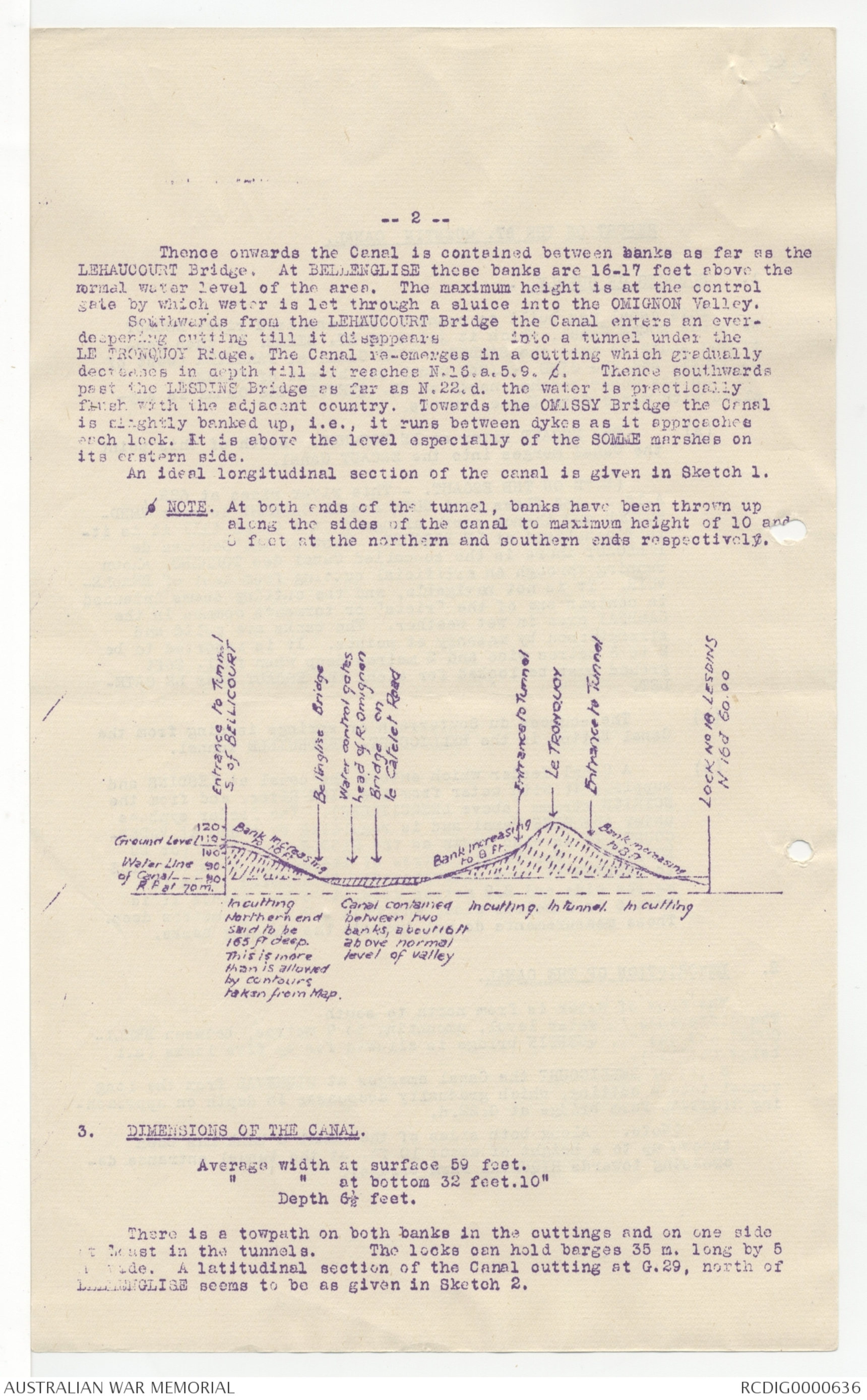
An ideal longitudinal section of the canal is given in Sketch 1.
o NOTE. At both ends of the tunnel, banks have been thrown up
along the sides of the canal to maximum height of 10 and
8 feet at the northern and southern ends respectively.
Diagram - see or4iginal document
3. DIMENSIONS OF THE CANAL.
Average width at surface 59 feet.
" " at bottom 32 feet. 10"
Depth 6½ feet.
There is a towpath on both banks in the cuttings and on one side
it [[?ast]] in the tunnels. The locks can hold barges 65 m. long by 5
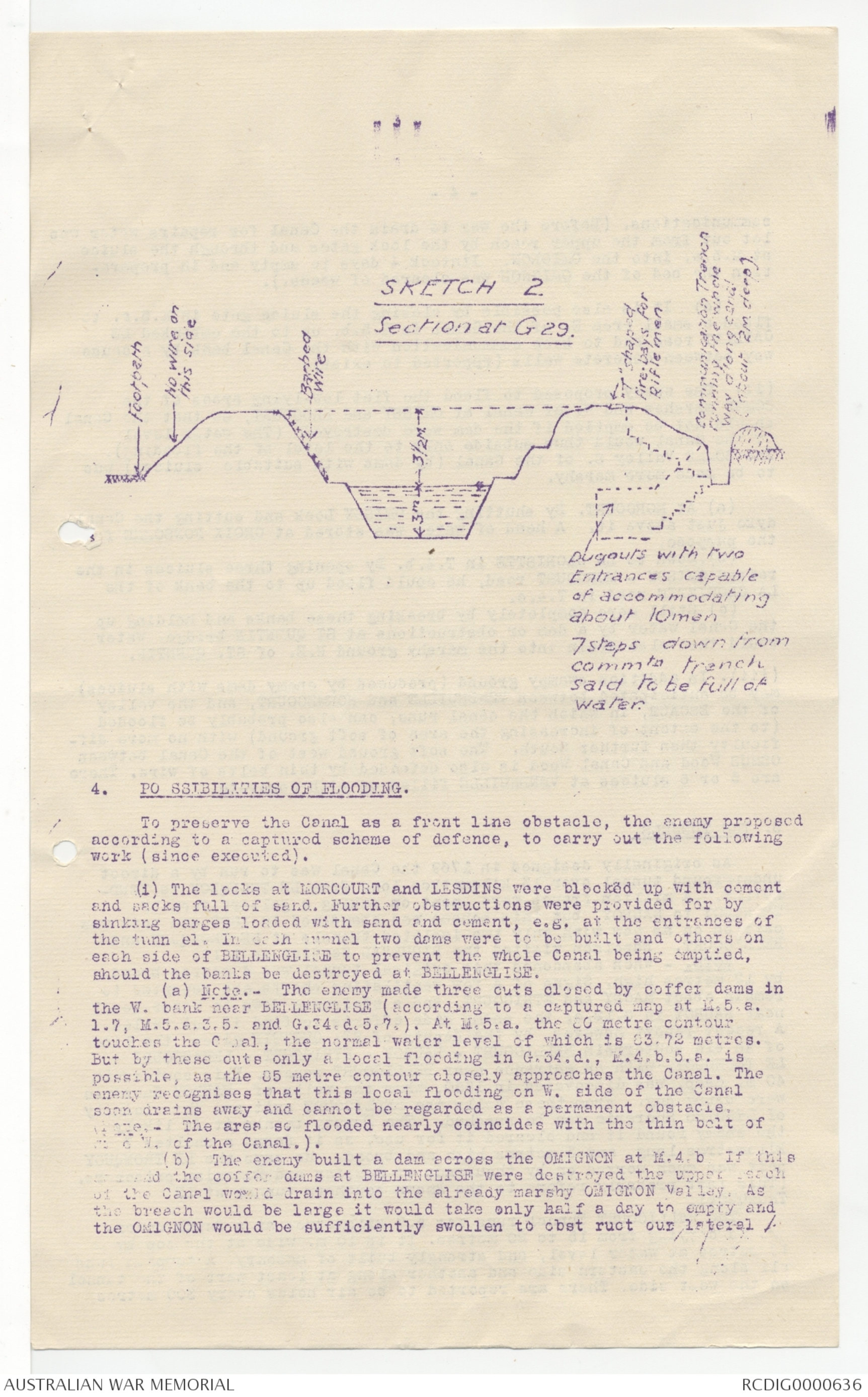
m wide. A latitudinal section of the Canal cutting at G.29, north of
BELLENGLISE seems to be as given in Sketch 2.
-- 3 --
SKETCH 2
Section at G29.
Diagram - see or4iginal document
4. PO SSIBILITIES OF FLOODING.
To preserve the Canal as a front line obstacle, the enemy proposed
according to a captured scheme of defence, to carry out the following
work (since executed).
(i) The locks at MORCOURT and LESDINS were blocked up with cement
and sacks full of sand. Further obstructions were provided for by
sinking barges loaded with sand and cement, e.g. at the entrances of
the tunn el. In each tunnel two dams were to be built and others on
each side of BELLENGLISE to prevent the whole Canal being emptied,
should the banks be destroyed at BELLENGLISE.
(a) Note. - The enemy made three cuts closed by coffer dams in
the W. bank near BELLENGLISE (according to a captured map at N.5.a.
1.7, M.5.a.3.5. and G.34.d.5.7.). At M.5.a. the 80 metre contour
touches the Canal, the normal water level of which is 83.72 metres.
But by these cuts only a local flooding in G.34.d., M.4.b.5.a. is
possible, as the 85 metre contour closely approaches the Canal. The
enemy recognises that this local flooding on W. side of the Canal
soon drains away and cannot be regarded as a permanent obstacle,
at ORE, - The area so flooded nearly coincides with the thin belt of
[[?]] [[?]] W. of the Canal. ).
( b ) The enemy built a dam across the OMIGNON at M.4.b. If this
area and the coffer dams at BELLENGLISE were destroyed the upper reach
of the Canal would drain into the already marshy OMIGNON Valley. As
the breech would be large it would take only half a day to empty and
the OMIGNON would be sufficiently swollen to obst ruct our lateral
- 4 -
communications. (Before the war to drain the Canal for repairs water was
let out from the upper reach by the lock gates and through the sluice
at M.5.a. into the OMIGNON. Itntook 4 days to empty and in preparation
the bed of the OMIGNON was cleared of weeds.).
(c) It is also possible by closing the sluice gate in M.5.a. to
flood a small area E. of the Canal in M.5.b. up to the embanked LE -CATELET
road and to keep communication with the Canal bank by a cause
way between concrete wells (rpeported to exist) .
(ii) The enemy proposed to flood the flat low-lying areas of the
SOMME marshes and W. of the Canal at OMISSY and BROCOURT, so that the Canal
should not be emptied if the dam were destroyed. (The water level
of the Canal would thus subside only to the level of the flooding).
The SOMME Valley S. of the Canal (by dams with suitable sluices) was
to be made more marshy.
(a) At MORCOURT. By shutting the OMISSY Lock and cutting the Canal
dyke just above it. A head of water was stored at CROIX FONSOMME for
the purpose.
(b). Down to LA GLORISTTE in T.4.b. By opening three sluices in the
raised OMISSY - MORCOURT road, he could flood up to the bank of the
LA GLORIETTE road in T.4.c.
(c). Still more completely by breaking these banks and holding up
the Canal water by a dam or obstructions at ST QUENTIN bridge. Water
would then also drain into the marshy ground N.E. of ST. QUENTIN.
(iii). In addition to swampy ground (produced by enemy dams with sluices)
may be anticipated between VENDHUILLE and HORMECOURT, and the valley
of the ESCAUT, in which the canal runs, can also probably be flooded
(to the extent of increasing the area of soft ground) with no more difficulty
than further South. The soft ground west of the Canal between
OSMUS Wood and Canal Wood is also defended by thin belts of wire. There
are 5 or 6 sluices at VENDHUILLE filled up with concrete.
5. THE TUNNELS.
As originally designed in 1769 the Canal was to run by a direct
underground tunnel over 13 kilometres long from LE TRONQUOY to VENDHUILLE.
A million francs were spent on making a gallery from LE TRONQUOY
to NAUROY, but this scheme was abandoned in 1802 and work was
carried on as now with only two isolated tunnels at LE TRONQUOY and
BELLICOURT. Napoleon visited the REQUEVAL Section in 1810.
NOTE. - When abandoned this original tunnel was 4 metres broad
by 12 metres high, Signs of a few ventilating shafts are reported to
remain about MAGNY and ETRICOURT, and a staircase down to water-level
near NAUROY in G.12.c; the enemy made efforts to find it but failed.
A recent report however, by the deputy of ST. QUENTIN gives the line
of an old souterrain BELLICOURT - NAUROY - ETRICOURT - LEHAUCOURT -
LE TRONQUOY, with an entrance near BELLICOURT square. This souterrain
40 m. deep, was discovered in 1880, when the wells of NAUROY Sucrerie
of LESDINS Sucrerie can be reached. The Deputy thinks it is likely
the enemy found it and cleared it for use, as it forms a shelter 7
kilometres long, and 3 metres high and broad, He says the LE TRONQUOY
part was much worked on by thousands of Russian and Rumanian prisoners.
(This last probably refers to the known southern tunnel at LE
TRONQUOY).
The BELLICOURT Tunnel runs for 5.7 kilometres at a depth under-
ground carying from 15 to 20 metres. It is 10 m. wide at the top by
18 metres at water level, and strongly built of masonry. A towpath runs
all along the eastern side and another along at least part of the tunnel
on the west side. There are reported to be air holes every 300 metres
- 5 -
and also chambers cut in the walls.
Early in 1918 there were 25 barges in the tunnel north of the
BELLICOURT block in G.16.a. used for billets: according to recent
prisoners those barges are now broken up or sunk. There are footbridges
across the water bed.
Prisoners in 1917 stated that there were four or five approach
galleries about 30 metres apart with entrances (30 or 40 steps down)
on the W. side of the road about G.10.c.6.5. The location of these
lateral galleries is fixed by captured German maps which show a gallery
from G.10.c.7.6. to exit at G.10.c.1.6. and other entrances at G.10.
c.75.45., G.16.a.80.85., G10.a.70.25 and G.10.a.84.53. of galleries
leading down to the tunn el. Some of these are discernible on photographs.
The German map also shows 3 galleries into the Canal cutting
just south of RIQUEVAL - exits at G.16.b.1.3./ G.16.b.18.23 and
G.16.d.22.88. (in addition a prisoner reports another exit in a cellar
of a villa at G.10.2.30.55, and the that the shaft at G.10.c.45.60, has
an exit on the BELLICOURT Road).
Those galleries are confirmed by maps and by a prisoner of an
Electric Power Company whose engine was in one of the chambers cut in
the east wall of the tunnel at BELLLECOURT.
No German map is available for the main length of the tunnel
north of BELLICOURT to near VENDHUILLE. According to prisoners'
statements in 1917 there were 15 underg round galleries leading from
the GOUY - BELLECOURT Road into the tunnel. These would enable to
enter or leave the tunnel unobserved. As far as can be gathered from a
recent prisoner, he emerged from one of these lateral galleries close
to the GOUY - BELLICOURT Road at G.22.c. There is little trace of
such exit on photographs as they are camo uflaged with brush wood.
According to a prisoner there are about 9 such galleries from the
tunnel between BELLICOU RT and BONY.
Apart from the air shafts shown along the tunnel, there is a series
of dugouts cut into the east bank of the long spoil heap which runs
above ground over the line of the tunnel. It does not seem likely that
these dugouts lead down into the tunnel, as the latter is 15 to 50
metres below.
It is possible that there are also galleries leading west from the
tunnel to exits shown along the HINDENBURG support line.
NOTE.- (In case of an attack by our troops across the GOUY - BELLICOURT
tunnel, it would be of the most extreme importance (a) for the
HINDENBURG support line to be garrison throughout the length running
from A.9.d. - 15..b and d - 21.b. and d. - 27.b. and d. - G.3.b. and
d. 9.b. and 10.c; ( b ) for the dugouts along the top of the tunnel to
be similar, but with no machine gun openings. The blocks fill the entire
tunnel from the water level to the roof, and are passed by means of a
door on the tow path (see skteetch below). There is a large concrete
machine gun nest at S. entry to tunnel at N.W. corner of the cutting
(G.1.6.a.7.6.), and there are other M.G. emplacements here to enfilade
the open canal.
For BELLICOURT and the RIQUEVAK tunnel
II. The LE TRONQUOY Tunnel.
This tunnel runs for 1. km at LE TRONQUOY under Hill 127. On
the ground above the tunnel passes the LEHAUCOURT 0- LES DINS road on an
embankment gradually dwindling towards each end of the tunnel.
- 6 -
There are reported to be 30 chambers cut in the walls of the tunnel
at reg ular intervals and connected by a passage. Barges hare are also
said to have been used for billets and ammunition.
A captured German map (1/5,000) gives accurately the lateral
galleries s to this tunnel. Entrances are marked at N.2.d, 05.30, N.2.d.35.15.
N.9.a.03.58 and N.9.a,3.3, of four short galleries leading into
the tunnel. These entrances coincide with holes or dugouts clearly
visible on photographs. No tracks lead up to those, and it is
probable they are only used as emergency exits. In addition map also
shows a long lateral gallery with entranc e (from a dugout known to
exist) in FLECH WOOD, N.3.c.4.7. and leading to the tunnel at H.8.b.3.8
and further W. exit in a trench dugou t at N.8.b.2.3. near TREHCHEE
WOOD.
This map confirms previous prisoners' statements describing the
tunnel as having 6 lateral galleries branching east at intervals of
200 yards. There is also apparently a communication from above at by
shafts 20 feet by 10 feet.
III. The BELLENGLISE Galleries.
(a) MAGNY Tunnel.
A captured German map shows a tunnel running from the eastern
edge of the wood in G.36,a. to the northern outskirts of BELLENGLISE
at G.35.c.25.8 5., with another entry from the BELLIOOURT road at
G.35.b.10.13.
The prisoners of the Electric Power Coy. mentioned above desc ribed
this tunnel in Feb., l9l8 as 1½ metres broad and 2 metres high, with 4
additional exits in BELLENGLISE close to Church at G.34.d.90.85,
G.55.c.08.53, G.55.c.10.75 and G.35.c.l4.72. These galleries enter the
main tunnel at about G.35.c.25.85. A prisoner could also locate one
at G.35.a.10.33, which led to the Starkstrom Kommande Station supplying
electric light to the tunnel. This last named location is doubtful.
It is certain that the tunnel goes further east than the point
marked on the map (G.35.b.) and that it emerges near MAGNY. In February
1918 prisoner could not definitely locate it, but it was near the cross
roads at H.25.a.30.25. A Pioneer prisoner states that on September 18th
1918 his company and an infantry regiment used this tunnel from HMAGEY.
The entrance is apparently about H.31.a.6.8 (where photographs show a
dugout in a trench) and the tunnel, which is not quits straight, runs
for over 2 kilometres via BELLENGLISE to ab out 100 yards of the canal.
It is revetted with wood, and there are a series of 16 dugouts as well
as a trench tramway, inside the tunnel. Traffic is facilitated by
switch tunnels which are also provided with dugouts.
Prisoner in Feb. 1918 stated that the tunnel contained a dressing
station, canteen and a kitchen. One battalion was quartered here in
reserve and at least another could be put in. There were several air
shafts and an electric fan.
(b) In addition, a previous prisoner stated that there were
at BELLENGLISE two straight approach galleries to the Canal about 35 m.
apart with entrances on W. side of road at G.34.d.96.90. The galleries
were 40 m. long, 1.8 m. high and 1.2 m. broad, revetted with wooden
frames.
6. QUARRIES.
The Quarry in G.l6.d. contains important accommodation for
troops, including in the northern face, a gallery capable of holding
at least a battalion. This gallery has three entrance shifts and 3 large
[[?]]. There are also 2 large dugouts in the W. face side by side
with several in the eastern face, probably capable of holding a large
number of men. The re used to be two anti-aircraft machine guns
- 7 -
emplaced near the dugouts in the W. face. The North-eastern corner
con tained a large dugout, then used as Regimental Battle H.Q. There
was a Battalion H.Q. in the dugouts shown on the l/10,000 map at G.22.b355385.
NOTE. - This quarry is of great tactical importance. Its garrison
is undoubtedly intended to attack our troops in flank should
they succeed in crossing the Canal tunnel south of BELLICOURT.
Its importance is referred to in the HINDENBUBG defence scheme.
7. BRIDGES. -
Bridges exist as indicated on the maps and fully described in
topographical reports. In addition, there are many footbridges at short
intervals along the Canal.
The bridges occur at narrowin gs of the Canal, and are raised about
3 to 4 metros above the water level. They are nearly all fixed iron
bridges on stone foundations, many as at BELLENGLISE and LEHAUCOURT
having two spans (20 metres long). The PONT de RIQUEVAL at G.22.d.,
however, is of solid mason ry, and so is the ST. QUENTIN Bridge (double*arched,
with ston e pier in centre of Canal. In addition there are
bridges over the river SOMME E. of the Canal at ST. QUENTIN, MORCOURT
and ROUVROY.
8. PRESENT CONDITION OF CANAL.
The Canal is now practically empty between the locks in HONNECOURT
and from the lock in S.l3.d. to the northern end of the tunnel near
LE CATELET. South of the lock, in S.13.d. to VENDHUILLE the water
consists mainly of small pools. The bottom appears very muddy. The
existence of bridges over the channel E. of the Canal N. of VEHDHUILLE
without corresponding bridges over the Canal itself would indicate that
the bed is passable for foot traffic at certain points.
9. TRENCHES: The SIEGFRIED Stalling.
The enemy chose the line of the Canal to take advantage of the
latter as a natural obstacle. But there is much evidence that from
BELLICOURT to BST. QUENTIN the o riginal scheme was not quite maintained.
He at first chose the E. bank as his main line of resistance and
proceeded to sink shafts at frequent intervals from the topoof the
east barnk to connect with dugouts which would again connect with a
circulating trench running under the lee of the bank. A support line
was planned 150 yards behind this on the higher ground. Then,
perhaps because the dugouts filled with water draining from the Canal,
he abandoned the bank its elf as his mnin line; the shafts were
replaced by small fire bays at intervals, connected with the circulating
trench( in recent photographs these fire bays appear neglected) He
was now obliged to draw back his line to higher ground, in order to
command grou nd otherwise dead.
This probably explains the series of holes, apparently purposeless,
visible in some parts between the east bank und the present main HIHDENBURG
line. They represent the dugouts of a projected line not
carried out (work was on the usu al SIEGFR1ED 1ine principle, starting
first o n the dug outs).
Captured German secret maps of February, 1917 show in detail the
HINDENBURG line as projected on that date, and as since executed.
The Canal obstacle was enhanced by wire on the innder side of the
'. bank and by felling the trees and leaving the stumps interlaced with
wire. The bridges are ready mined and the approached defended by machine
guns.
The HINDENBURG line as projected in 1917 was based on principles
of defence since obsolete. It was executed on these principles even
up to March, l9l8, perhaps because the enemy felt reliance on its
un usual strength and that it could not be attacked.
- 8 -
The front line was provided with concrete dugouts at 40 or 50
yards interval: the captured maps show all the machine guns in the front
and support lines, and the artillery not disposed in depth.
Modifications must now be expected in these directions.
but even for the HINDENBURG line the enemy was careful to keep a
series of forward positions to deny observation and in 1918 did much work
on outpost lines. These were strongly elaborated between PONTRUET and
the bastion of the HINDENBURG Line enclosing the city of ST. QUENTIN.
Where the natural obstacle of the Canal is lacking, i.e, at the
long tunnel between VENDHUILLE and BELLICOURT and the shorter LE TRONQUOY
tunnel, the enemy organised particularly strong and well wired
trenches in the form of a slight saliant. The wire is particularly
strong, the forward belt being in the form of triangles characteristic
[[?]] of the DROCOURT - QUEANT line.
E. of VENDEUILLE the HIHDENBURG line is drawn well back from the
Canal and goes north past LA TERRIERE to rejoin the Canal at BANTOU ZELLE.
In this sec tor, also, the wire is of similarly strong character.
At BANTOUZELLE the system crosses the Canal, runs N.W. to MOEUVRES and
QUEANT - now in our hands.
Work before March. 1918.
From January, 1918 a considerable amount of work was noticed on
outpost lines, e.g. much wiring end work on trenches was done near
OSSUS WOOD and in the PON TRUET - THORIGNY - ST. QUENTIN area. In the
latter area there appeared a conziderable number of wired-round strong
points.
There was much activity on the repair of road s, the making of new
military roads, especially at ITANCOURT and to the Canal bridges. New
tramways were built and the enemy increased his footbridges and
causeways and made several bridges for heavy traffic.
Recent work.
Since we again approached the HINDENBURG Line work on that system
has not been so conspicuous as might be expected. On the 15th Sept.
photographs showed various new lengt hs of trench: across the ridge E.
of BELLENGLISE from G.29.c, to G,36.c., across KNOBKERRY RIDGE from
G.24.c. to G.30.b.; from NAUROY at G.11.d. across the RIQUEVAL ravine
and BELLICOURT ridge to the tunnel at A.28.c. (with some gaps) [[?id]]
A.23.c.d: along the LE CATELET - BELLICOURT road in A.11.c.16.b.;
and along the Canal north of VENDHUILLE. Since then no new trenches have
appeared but activity and work on trenches is visible, especially at
BONT and BELLIENGLISE. The work done has been noticeably
slight in the LEHAUCOURT - LESDINS - ST~ QUENTIN area. In general, how
ever, the HINDENBURG Line was ready before and remained in good condition
the wire is excellent.
Little or no work has been recently done on back lines behind the
HINDENBURG Line, e.g., the LE CATELET - NAUROY - MAGNY Line, a single
trench with dugouts, not very heavily wired, and on the MASNIERES
BEAUERVOIR line, which is more heavily wired and consists of front and
support trenches. Behin d this is the WALINCOURT - AUDIGNY line, mostly
merely trarced.
On the other hand, the enemy evidently does not wish us to approach
too close to the HINDENBURG Line, and he did a good deal of work on
various outpost lines, e.g., GILLEMONT Farm - QUENNEMONT Farm. In
particular the FLESNOY - FAYET Ridge was strongly organised with new
trenches and considerable belts of tire.
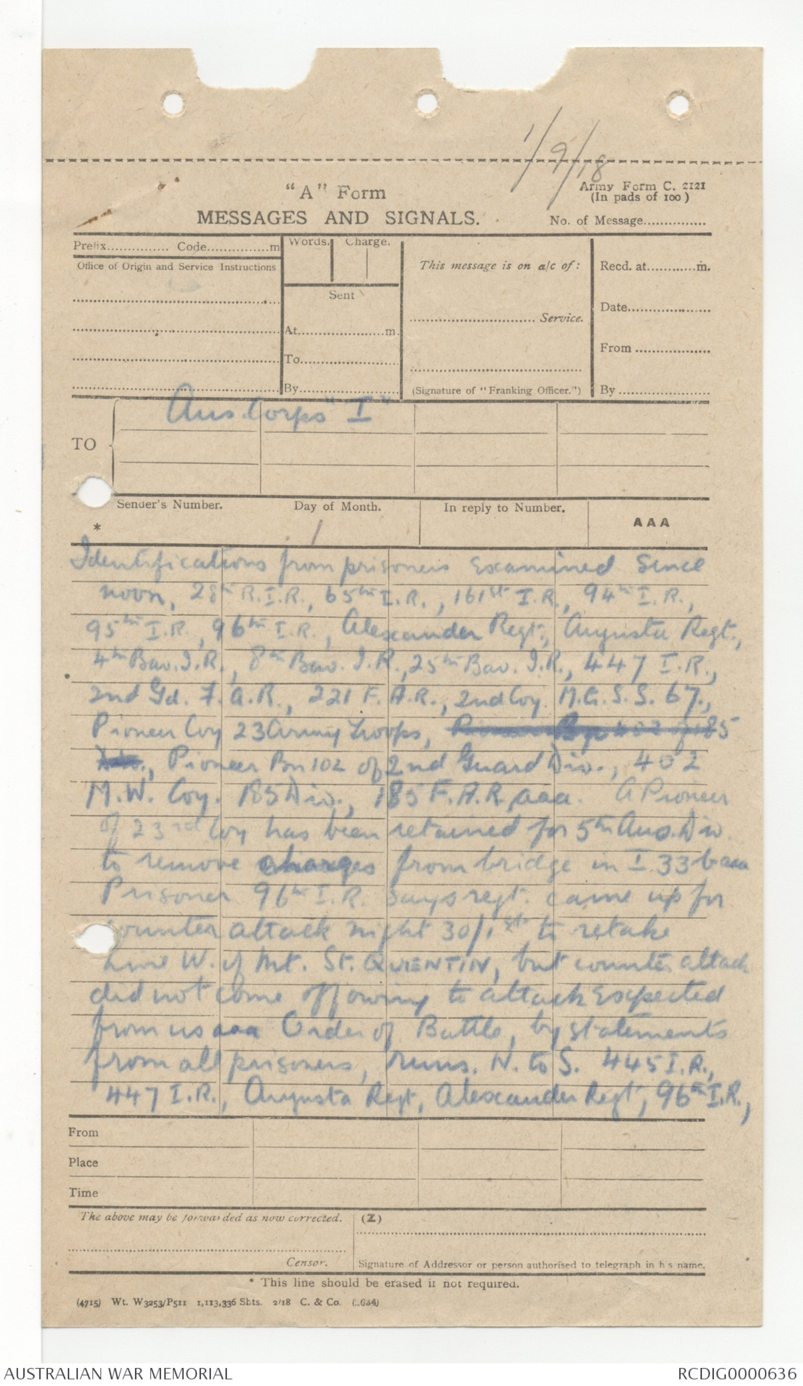
1/9/18
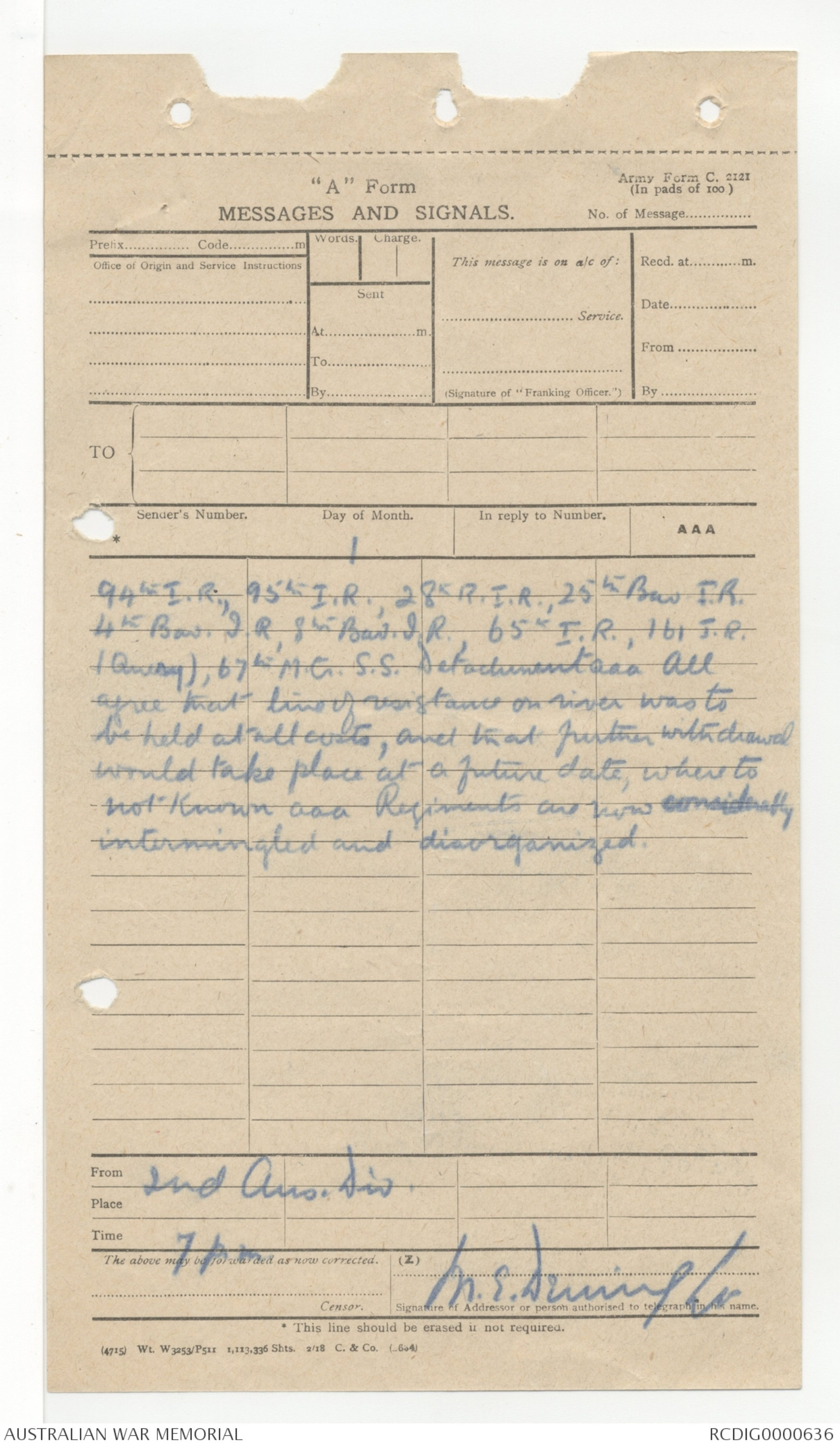
"A" Form
MESSAGES AND SIGNALS
TO { Aus Corps I
Senders Name
Day of Month 1
AAA
Identifications from prisoners examined since
noon, 28th R.I.R., 65th I.R., 161st I.R., 94th I.R.,
95th I.R., 96th I.R., Alexander Regt., Augusta Regt,.
4th Bav. J.R., 8th Bav. J.R., 25th Bav. J.R., 447 I.R.,
2nd Gd. F.A.R., 221 F.A.R., 2nd Coy. M.G. S.S. 67.,
Pioneer Coy 23 Army Troops, Pioneer Bn of 402 of 85Div., Pioneer Bn 102 of 2nd Guard Dov., 402
M.W. Coy. 185 Div., 185 F.A.R. aaa. A Pioneer
of 23rd Coy has been returned for 5th Aus. Div.
to remove charges from bridge in I.33b aaa
Prisoner 63th I.R. says regt. came up for
counter attack night 31/1st to retake
Line W. if Mt. St. QUENTIN, but counter attack
did not come off owing to Attack expected
from us aaa Order of Battle, by statements
from all prisoners, runs, N to S. 445 I.R.,
447 I.R. Augusta Regt, Alexander Regt, 93th I.R.,
94th I.R., 95th I.R., 28th R.I.R., 25th Bav. J.R.,
4th Bav. J.R., 8th Bav. J.R., 65th I.R., 161 J.R.
(Query), 67th M.G. S.S. detachment aaa All
agree that line of resistance on river was to
be held at all costs, and that further withdrawal
would take place at a future date, where to
not known aaa Regiments are now considerably
intermingled and disorganized,
From 2nd Aus. Div.
 Sam scott
This transcription item is now locked to you for editing. To release the lock either Save your changes or Cancel.
This lock will be automatically released after 60 minutes of inactivity.