General, Sir John Monash, Personal Files Book 20, 15 August - 8 September 1918 - Part 16
-4-
BELLENGLISE, from which there is a good field of fire
across the canal, calls for the employment of machine
guns from points in rear.
Our own infantry will be materially assisted if the
descent of the enemy's infantry from the high ground to the
west and south of BELLENGLISE, and its establishment along
the canal, is hindered as far as possible by our artillery
fire. The bare hills on the other side of the Canal
must be kept under as close observation as the ground along
the east bank. The enemy has nothing to assist him in the
way of cover, and will be obliged to construct everything
under our fire. This advantage must be made use of and
the smallest attempt at digging must be kept under fire.
The infantry will also have to assist from the outset in
keeping the enemy at a distance, particularly by means
of harassing fire at night.
In case the enemy should succeed in crossing the
canal at any point, the preparation of BELLEGLISE village
for obstinate all-round defence is of special importance.
Should we succeed in bringing the enemy to a stand close
to the canal, it will be extremely difficult for him to
advance further with this obstacle close behind him.
DIVISIONAL SECTOR NO. 3.
SHORT SKETCH OF THE TACTICAL PECULIARITIES OF THE SECTOR.
The SOMME canal is carried under the LE TRONQUOY Ridge
through a tunnel. At this point, therefore, it is only
necessary to consider it from the point of view of providing
shelter. The want of a natural obstacle must be compensated
for by the construction of strong defences. The ridge
between THORIGNY and LE TRONQUOY, if not held by us, would
afford the enemy a good view into a great part of Sector 3.
For this reason, until the enemy brings up considerable
forces, the ridge must be held by outposts. For the adjoining
stretch from the LE TRONQUOY Ridge (excl.) to LESDINS
(Incl.), the only natural obstacle is the canal (without any
marshy border). South-east of LE TRONQUOY the canal cutting
is deep. Its west bank commands the east at many points,
so that any enemy approach work could be protected against
our infantry fire. These high banks on the western side,
moreover, afford good observation points over our defences,
which, with a view to sweeping the canal effectively, are
pushed forward close to the east bank at many points. The
occupation of this high ground by the enemy must therefore
be hindered as long as possible, in the first place by our
outposts, and later by systematic bombardment of every enemy
approach work by our artillery, which will find favourable
conditions for this purpose in the good observation to be
had from the high ground north-east and south-east of LESDINS
and in cross fire from both these directions.
The southern half of the sector, from LESDINS, (excl.)
to ROUVROY (excl.), it is protected by the front line obstacles
of the SOMME Canal and the low ground of the SOMME Valley.
The latter can be regarded as an effective obstacle in the
neighbourhood of ROUVROY only. The rest of it, however,
offers/
-5-
offers the advantage, that it is easy to sweep with fire,
and that the high level of the water table will hamper the
pushing forward of enemy entrenchments within assaulting
distance. The water level may be raised by damming. The
part of the sector that belongs to the ST. QUENTIN bridgehead
position is a reverse slope position. The right flank
rests on the low ground of the SOMME Valley. The foreground
of the position can be taken in flank by artillery fire from
the neighbourhood of TILLOY Farm. The town of ST. QUENTIN,
which lies close behind the position, offers suitable
artillery positions.
The ground behind the entire divisional front rises
in an easterly and north-easterly direction. The rear lines
of the 1st line position are thus exposed to enemy observation
to a very large extent. For bringing up troops under
cover, approach trenches are necessary, extending far into
the back area.
NOTES FOR THE DISTRIBUTION OF THE INFANTRY.
The northern half of the sector is the more dangerous.
The southern portion of the position, east of the Canal, is
protected by marshy ground. The northern front of the
town defences is effectively protected by the flanking
artillery support from the TILLOY Farm area. When distributing
the troops to hold Sector 3, therefore, it is advisable,
for a division consisting of 3 regiments, to allot 2
to the northern and 1 to the southern sector (see map).
In the southern sector, the relatively external nature
of the position renders it necessary to employ the 3 available
battalions side by side; about half of these may be
drawn upon to garrison the portion of the town defences
which belongs to sector 3.
NOTES FOR THE CONDUCT OF THE INFANTRY BATTLE.
For the conduct of the infantry battle the ground offers
no difficulty or special peculiarity. The defence of the
northern sector will be principally effected by the construction
of strong defences. The support of a number of
inconspicuous machine guns will be necessary for sweeping
the marshy ground.
It is of great importance that the enemy should be
prevented from pushing forward his lines over the slopes
running down to the canal, which are easy to observe from
our side.
DIVISIONAL SECTOR NO. 4.
SHORT SKETCH OF THE TACTICAL PECULIARITIES OF THE SECTOR.
(see also plan of the town).
Sector from the Stadium to the Roman Road ("Römerstrasse")
("Römerstrasse" is the name of the whole of the straight
road/
-6-
road from ST. QUENTIN to HOLNON).
From the Stadium (map square 3961, to the north of the
point where the track leading to THORIGNY branches off from the
ST. QUENTIN - LESDINS road) to the Roman road (centre of map
square 4159), the ground falls along the western edge of the
town in a depression which drains under the town in a southerly
direction into the SOMME. West of this low ground, the country
rises in narrow ridges to the heights north-east of FAYET.
East of the depression, it rises somewhat steeply to the
actual town of ST. QUENTIN. The 1st line of the position lies
on the eastern slopes of the ridges to the west and constitutes
a reverse slope position. Its field of fire, generally
speaking, is very restricted, owing to the rounded contours
of the slopes; the narrow depressions, however, which lie
between the ridges can be swept with fire from the 1st line.
Long stretches of the line can be seen into from the high ground
west of the Orphelinat (map squares 4257 and 58)-
The 2nd line in this part of the position line 200 or 300
metres behind the front line, for the most part in the low
ground itself. It can be seen into almost throughout its
length from the high ground west of the Orphelinat.
The 3rd line - not shown on the map - has been reconnoitred
and will lie on the outskirts of the town on the westward
slopes of the high ground on which stands the town of ST.
QUENTIN. Although this slope also can be observed from the
heights west of the Orphelinat as well as from the FAYET heights,
large portions of the line, being situated in gardens, are
invisible to the enemy. The communication trenches between
the three lines, and the intermediate zone in particular,
can, for the most part, be seen into from the opposite heights.
Sector from the Roman Road to the SOMME.
The area between the Roman Road and the low ground of
the SOMME Valley is filled by a ridge which falls gradually
from the Orphelinat to the town. The ST. QUENTIN - HAM railway,
which runs over the ridge in a curve, forms alternately
high embankments and deep cuttings. The Orphelinat lies
rather to the east of the highest (most easterly) point of the
ridge, which affords a wide view over the foreground as far as
the Stadium, to the Fayet Park, and to the heights above the
SOMME Valley to the South.
In this sector, the 1st line first of all follows the
narrow gauge railway, turns off from it to the south-west
through a hollow, rising to the highest point west of the
Orphelinat, which it encloses as a forward slope position, and
terminates at the canal, west of the ROCOURT Factory. North of
the SAVY road, it can be seen into from the high ground to the
north of the Roman road: south of the SAVY road, from the ridges
1 km. north-west of OESTRES and from the high ground of the
south bank of the SOMME.
With the object of providing a switch line for the 1st
line, which projects westwards like an advanced work, an
intermediate line, running through the Orphelinat Garden, has
been constructed as a reverse slope position.
The 2nd line crosses the Roman road east of the narrow
gauge railway, screened by the very high railway embankment,
then/
-7-
then rises across undulating country and disused clay pits to
the SAVY road, follows the light railway a little way and
terminates in the western half of ROCOURT factory. Only a
small part of it can be seen into by the enemy.
A 3rd line, intended as an artillery protective line,
(not shown on the 1 : 25,000 map), runs through houses and
clay pits to the park east of ROCOURT factory; it is almost
entirely under cover.
The SOMME Valley and SOMME - Windmill Sector.
The low ground of the SOMME Valley comprises a swampy
stretch of country about 500 metres wide, covered with woods
and undergrowth, intersected by numerous dykes in addition to
the canal. The roads across this area are built along low
embankments, the railway embankment is several metres high.
In the dry season, the ground off the roads is practicable for
small detachments. The 1st, 2nd and 3rd lines are constructed
on embankments; there are no approach trenches.
South of the SOMME, the sugar factory at LA BIETTE
constitutes a projecting strong point of the position, which
then rises to the windmill hill. Whereas here the 1st line,
which is a reverse slope position, can only be seen into from
the Fayet Park and the high ground north of the SOMME, the 2nd
line at this point is so far unfavourably situated that it is
open to observation from the ridge to the east of GAUCHY. The
3rd line - artillery protective line - lies far in the rear
at the exit from ST. QUENTIN.
As yet, no part of the 3rd line has been constructed.
The troops moving in will commence its construction immediately
as also that of further lines in the town with a view to its
defence by sectors.
NOTES FOR THE DISTRIBUTION OF THE INFANTRY.
The forces required on the entire divisional front are
approximately the same everywhere. Consequently the
divisional sector has been divided into 3 regimental sectors of
approximately equal width. (see map).
NOTES FOR THE CONDUCT OF THE INFANTRY BATTLE.
In the sector north of the ST. QUENTIN - SELENCY road,
the dominating position of the 3rd line points to the massing
of the greater part of the machine guns in its neighbourhood;
from the gardens and houses on the outskirts of the town they
can/
-8-
can fire over the two front lines and thus form an effective
barrage. Isolated machine guns between the 2nd and 3rd lines
can command and enfilade the low ground to the west of the
town. In the 1st and 2nd lines light machine guns will suffice.
The importance of the sector from the ST. QUENTIN -
SELENCY road to the SOMME depends on the possession of the
high ground west of the Orphelinat. This is the only point from
which the hollows to the south of FAYET can be seen into, which
are of importance for the deployment of the enemy's artillery
and reserves. This height must be held at all costs, and the
units (battalions) fighting there must be distributed in considerable
depth. As a continuous machine gun barrage from rear
positions cannot be put down in front of the height, the
employment in the front line of numerous light machine guns
is necessitated. Plans of methodical recapture of the
heights must be prepared beforehand in case the immediate
counter-attack following enemy penetration should fail in
its object.
The low ground of the SOMME Valley need only be protected
by picquets and patrols. The troops to the north and
south of this area must protect their flanks against enemy
raids in the SOMME Valley.
The sector south of the SOMME constitutes the right
wing of the defences of Windmill Hill, which is of importance
for our observation on account of its commanding view. The
siting of machine guns in the vicinity of the 2nd line will
render a flanking barrage possible in front of the positions
on the northern slope of Windmill Hill. For strengthening
the barrage in front of the LA BIETTE strong point, trench
mortars will be required. Plans for the methodical recapture
of the position, inclusive of the strong point, must be prepared
beforehand.
Fourth Army (Intelligence),
September 8th, 1918.
(E)
G.O.C.
APPENDIX "A" TO FOLIO I.
G.H.Q.No. Ia/54674.
Fourth Army, I. No. IG.103/5.
SHORT NOTES ON THE DAMS AND THE UTILIZATION OF
WATERCOURSES AS
A FRONT LINE OBSTACLE FOR THE 1ST SIEGFRIED LINE.
FROM BELLICOURT TO SOUTH OF ST. QUENTIN.
The highest level of the canal lies between the locks
LEBOUSQUET (First Army) and LESDINS. The Canal is fed by
the "Canal d'alimentation" (Rigole) at LESDINS (1,000 sl.).
In order to preserve the canal as a front line
obstacle, i.e., to prevent water draining away, the following
works were carried out :-
(a) The locks at MORCOURT and LESDINS were blocked
up with cement and sacks of sand. Any further obstruction
of the canal by sunken vessels, sandbags, and concrete
can be arranged for later, in case of necessity, by the
Corps H.Q. at ST. QUENTIN. For the time being, the canal
between MORCOURT and ROCOURT should be used behind the
bridgehead position as a waterway for barges. Vessels
and barges ready to be sunk are lying beside the main
road bridge in ST. QUENTIN.
(b) In each of the tunnels at BELLICOURT and LE
TRONQUOY two dams should be constructed, with 4 others
on each side of BELLENGLISE, in order to shut off the
water and prevent the whole Canal being emptied, should
it be destroyed at BELLENGLISE where its level is higher
than the level of the surrounding country. Artificial
flooding on the west side of the canal, south of
BELLENGLISE, soon drains away and cannot therefore be
regarded as a permanent obstacle.
(c) Flat, low-lying areas (west side of canal at
OMISSY and BROCOURT) should be inundated so that the
Canal shall not be entirely emptied if the dam is destroyed.
The water-level of the canal will then only
subside to the level of the inundations.
(d) Damming of the canal at ROCOURT.
All dams and locks only hold back the water up to its
normal height and allow any additional water to overflow.
In addition to the canal, the low ground of the SOMME
valley, east of the canal, can also be utilized as a good
front line obstacle. The naturally marshy ground will be
rendered more swampy by constructing dams with suitable
sluices. This can be done between LESDINS and LA BIETTE,
at and north of MORCOURT, MOULIN BRULE, ROUVROY, ST.
QUENTIN bridge, railway bridge at ROCOURT, and LA BIETTE.
The water level of these inundated areas can be
regulated by sluices in the canal just north of the ST.
QUENTIN bridge. For information as to the proposed constructions
for the maintenance of the canal level and
for the inundations, see 1.5,000 Map Part III, Enclosure 1
of this Memorandum.
Fourth Army (Intelligence),
September 8th, 1918.
8/9/18
B.G.G.S.
(a) Birdwood coming
(b) no leave.
1. Replacement of Connelly, GII of III Div.
(Major Norman 12th Bde)
2. A Bgde of 1st Div. - Gillibrand to have a call on,
pending relief. -
3. Lt Col. Mason - Corps School - hand over & leave
Hobbs wishes to see.
4. Lt Scullie - Corps School - wanted as Adjutant, by Elliott
5th Div. may be able to give another man.
5. C.E. to see re bridge at ATHIES, repaired.
6. When does 1st Div. arrive
7. Inter divisional Boundary.
8. Conference of 1st & 4th Divs. re capture of
Brown Line - define it more precisely.-
Bishop of Amiens
Evêché
d'Amiens
Amiens le 8 Sept 1918
Mes Frères
Avant de tirer du
mystère de ce jour de la nativité
de Marie la legou qui conneut
d' ur ãmes, permettez-moi
de rendre un particulier
hommage aux Divisions Australiennes
qui, par leurs victoires
sur ler hauteurs du Hamel
ont priludé aux magnifique
written in French - see original document
written in French - see original document
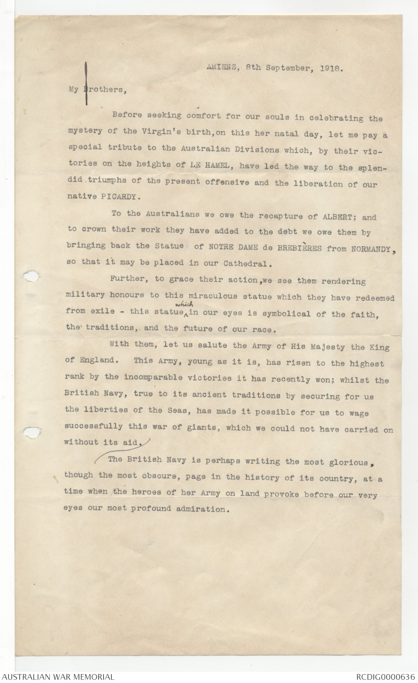
AMIENS, 8th September, 1918.
My Brothers,
Before seeking comfort for our souls in celebrating the
mystery of the Virgin's birth, on this her natal day, let me pay a
special tribute to the Australian Divisions which, by their victories
on the heights of LE HAMEL, have led the way to the splendid
triumphs of the present offensive and the liberation of our
native PICARDY.
To the Australians we owe the recapture of ALBERT; and
to crown their work they have added to the debt we owe them by
bringing back the Statue of NOTRE DAME de BREBIÈRES from NORMANDY,
so that it may be placed in our Cathedral.
Further, to grace their action, we see them rendering
military honours to this miraculous statue which they have redeemed
from exile - this statue ^which in our eyes is symbolical of the faith,
the traditions, and the future of our race.
With them, let us salute the Army of His Majesty the King
of England. This army, young as it is, has risen to the highest
rank by the incomparable victories it has recently won; whilst the
British Navy, true to its ancient traditions by securing for us
the liberties of the Seas, has made it possible for us to wage
successfully this war of giants, which we could not have carried on
without its aid.
The British Navy is perhaps writing the most glorious,
though the most obscure, page in the history of its country, at a
time when the heroes of her Army on land provoke before our very
eyes our most profound admiration.
 Sam scott
This transcription item is now locked to you for editing. To release the lock either Save your changes or Cancel.
This lock will be automatically released after 60 minutes of inactivity.