Written Records, AWM54 741/5/9 PART 2 - [Patrols - Reconnaissance:] Report on Northern Territory Special Reconnaissance Unit, by Sqn Ldr D F Thomson RAAF [Report minus maps] - Part 23
13.
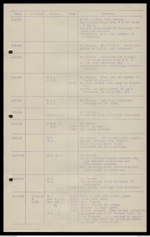
| Date | Courses | Winds | Time | Remarks |
| 2/2/42 | At No. 3 Buoy Port Darwin | |||
| Torrential rains from W & NW force 6 Sea 3. Private Richardson to Hospital for test for malaria. Impossible to do any loading or refuelling. |
||||
| 3/2/42 | At Darwin. Wind N.W.6. heavy rain. | |||
| Ashore at D.F.O. and Ordnance. | ||||
| 4/2/42 | At Darwin. Overcast and cloudy, | |||
| with fresh winds from N.W. 5. Native crew received pay. Arrangements for refuelling unsatisfactory. |
||||
| 5/2/42 | N.W.4 | At Darwin. Fuel and oil landed on | ||
| C.C.R. | wharf by A.A.S.C. | |||
| 1930 | Shifted vessel from buoy to Francis | |||
| Bay. Loaded 100 gals petrol 20 gals kerosene, 15 gals lub. oil. |
||||
| 6/2/42 | N.W.3 | At Darwin. American armourers | ||
| C.C.R. | working on .50 guns. | |||
| 7/2/42 | N.W.3 | At Darwin. | ||
| O.C | Loaded 20 X 44 gals drum diesoline. | |||
| 8/2/42 | N.N.W. 3 | At Darwin. | ||
| O.C. | 1650 | Alert sounded. | ||
| 1820 | All clear sounded. | |||
| 9/2/42 | W.3 | At Darwin. Occasional rain squalls. | ||
| B.C. | Loaded rations from Vesty's. | |||
| Crew filling water tanks Armourers on gun mountings. |
||||
| 10/2/42 | W.2 B.C. | At Darwin | ||
| King's Harbour Master reports sea and weather conditions not favourable outside. Gun mounting still unsatisfactory taken back to workshops. |
||||
| 11/2/42 | W.1. S.C. | At Darwin | ||
| Gun mounting still in hands of | ||||
| mechanics. | ||||
| 1800 | Gun mounts returned from workshops. | |||
| 12/2/42 | Various | W.1 | 0720 | Hove up and left under power. |
| N. | Sea 1 B.C. | 0800 | Clear Boom Gate. | |
| N.XE. | Sea 1/B.C. | 0845 | Alt. Course. | |
| W1 | 1150 | South Vernon Is. abeam. | ||
| 1210 | Reduced to half speed. | |||
| 1220 | Vessel touched. 1240 Vessel refloated | |||
| W.3 C | Anchored lee of S. Vernon Isld. In | |||
| 5 fathoms. O.C ashore in launch for some hours on reconnaissance. Distance travelled 32' |
14.
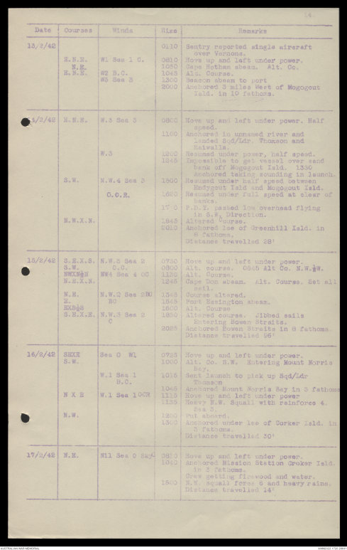
| Date | Courses | Winds | Time | Remarks |
| 13/2/42 | 0110 | Sentry reported single aircraft | ||
| over Vernons. | ||||
| R.N.R. | W1 Sea 1 C. | 0810 | Hove up and left under power. | |
| N.E. | 1030 | Cape Hotham abeam. Alt. Co. | ||
| E.N.E. | W2 B.C. | 1045 | Alt. Course. | |
| W3 Sea 3 | 1300 | Beacon abeam to port | ||
| 2000 | Anchored 3 miles West of Mogogout | |||
| Isld. in 10 fathoms. | ||||
| 14/2/42 | N.N.E. | W.3 Sea 3 | 0800 | Hove up and left under power. Half |
| speed. | ||||
| 1100 | Anchored in unnamed river and | |||
| landed Sqd/Ldr. Thomson and Raiwalla |
||||
| W.3 | 1200 | Resumed under power, half speed. | ||
| 1245 | Impossible to get vessel over sand | |||
| bank off Mogogout Isld. 1330 Anchored taking sounding in launch. |
||||
| S.W. | N.W. 4 Sea 3 | 1500 | Resumed under half speed between | |
| Endygout Isld and Mogogout Isld. | ||||
| C.C.R. | 1620 | Resumed under full speed at clear of | ||
| banks. | ||||
| 17 | F.D.Y. passed low overhead flying | |||
| in S.W. Direction. | ||||
| N.W.X.N. | 1845 | Altered Course. | ||
| 2010 | Anchored lee of Greenhill Isld. in | |||
| 8 fathoms. Distance travelled 28' |
||||
| 15/2/42 | S.E.X.S. | N.W. 3. Sea 2 | 0730 | Hove up and left under power. |
| S.W. | C.C. | 0800 | Alt. course. 0845 Alt Co. N.W.½W. | |
| NWXN½N N.E.X.N. |
NW4 Sea 4 OC | 1125 | Alt. Course. | |
| 1245 | Cape Don abeam. Alt. Course Set all | |||
| sail. | ||||
| N.E. | N.W.2 Sea 2[[?]] | 1345 | Course altered. | |
| N. | BC | 1545 | Port Essington abeam. | |
| EXS½S | 1600 | Alt. Course | ||
| S.E.X.E. | N.W.3 Sea 2 | 1850 | Altered course. Jibbed sails | |
| C | Entering Bowen Straits. | |||
| 2025 | Anchored Bowen Straits in 8 fathoms. | |||
| Distance travelled 96' | ||||
| 16/2/42 | SEXE | Sea 0 N1 | 0725 | Hove up and left under power. |
| S.W. | 1000 | Alt. Co. S.W. Entering Mount Morris | ||
| Bay. | ||||
| W.1 Sea 1 | 1015 | Sent launch to pick up Sqd/Ldr | ||
| B.C. | Thomson | |||
| 1045 | Anchored Mount Morris Bay in 3 fathoms | |||
| N X E | W.1 Sea 1 OCR | 1115 | Hove up and left under power. | |
| 1135 | Heavy N.W. Squall with rainforce 4. | |||
| Sea 3. | ||||
| N.W. | 1200 | Put aboard. | ||
| 1300 | Anchored under lee of Corker Isld. in | |||
| 3 fathoms. Distance travelled 30' |
||||
| 17/2/42 | N.E. | Nil Sea C Sky | 0810 | Hove up and left under power. |
| 1040 | Anchored Mission Station Croker Isld. | |||
| in 3 fathoms. Crew getting firewood and water. |
||||
| 1500 | N.W. Squall force 6 and heavy rains. | |||
| Distance travelled 14' |
15.
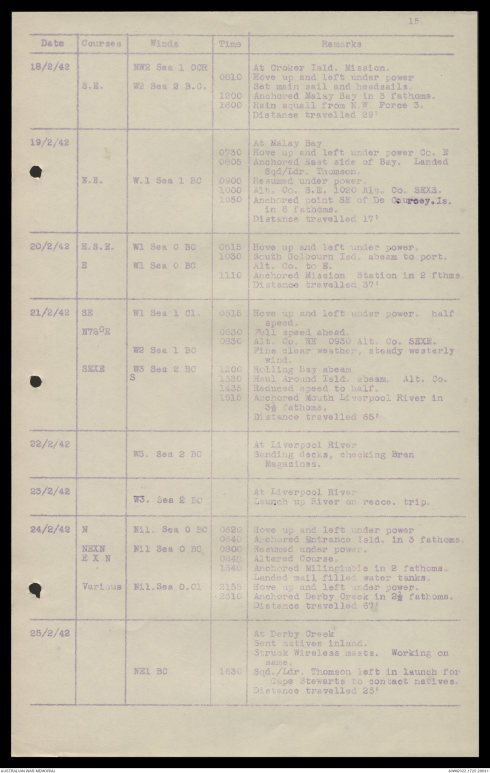
| Date | Courses | Winds | Time |
Remarks |
| 18/2/42 | N.W.2 Sea 1 OCR | At Croker Isld. Mission. | ||
| 0610 | Hove up and left under power. | |||
| S.E. | W2 Sea 2 B.C. | Set mainsail and headsails. | ||
| 1200 | Anchored Malay Bay in 3 fathoms. | |||
| 1600 | Rain squall from N.W. Force 3. | |||
| Distance travelled 22' | ||||
| 19/2/42 | At Malay Bay | |||
| 0730 0805 |
Hove up and left under power. Co. E Anchored West side of Bay. Landed |
|||
| Sqd/Ldr. Thomson. | ||||
| N.E. | W.1 Sea 1 BC | 0900 | Resumed under power. | |
| 1000 1050 |
Alt. Co. S.W. 1020 Alt. Co. SEXS. Anchored point SE of De Courcey. Is. |
|||
| in 6 fathoms. Distance travelled 17 ' |
||||
| 20/2/42 | E.S.E. | W.1 Sea C BC | 0615 | Hove up and left under power. |
| 1030 | South Golbourn Isd. abeam to port. | |||
| E | W.1 Sea C BC | Alt. Co. to E. | ||
| 1110 | Anchored Mission Station in 2 fthms | |||
| Distance travelled 37" | ||||
| 21/2/42 | SE | W.1 Sea 1 C1 | 0515 | Hove up and left under power, half |
| speed. | ||||
| N75°E | 0630 | Full speed ahead. | ||
| 0830 | Alt Co. NE 0930 Alt. Co. SEXE. | |||
| W.2 Sea 1 BC | Fine clear weather, steady westerly | |||
| wind. | ||||
| SEXE | W3 Sea 2 BC | 1200 | Nolling Bay abeam | |
| S | 1430 | Haul Around Isld. abeam. Alt. Co. | ||
| 1435 | Reduced speed to half. | |||
| 1515 | Anchored Mouth Liverpool River in | |||
| 3½ fathoms. Distance travelled 55" |
||||
| 22/2/42 | At Liverpool River | |||
| W 3. Sea 2 BC | Sanding decks, checking Bren | |||
| Magazines. | ||||
| 23/2/42 | At Liverpool River | |||
| W 3. Sea 2 BC | Launch up River on recce. trip. | |||
| 24/2/42 | N | Nil. Sea O BC | 0620 | Hove up and left under power. |
| 0640 | Anchored Entrance Isld. in 3 fathoms. | |||
| NEXN | Nil. Sea O BC | 0800 | Resumed under power. | |
| E X N | 0840 | Altered Course. | ||
| 1340 | Anchored Milinginable in 2 fathoms. | |||
| Landed mail filled water tanks. | ||||
| Various | Nil. Sea O CI | 2155 | Hove up and left under power. | |
| 2310 | Anchored Derby Creek in 2½ fathoms. | |||
| Distance travelled 67' | ||||
| 25/2/42 | At Derby Creek | |||
| Sent natives inland. Struck Wireless nests. Working on same. |
||||
| NE1 BC | 1530 | Sqd/Ldr. Thomson left in launch for | ||
| Cape Stewarts to contact natives. Distance travelled 25' |
16.
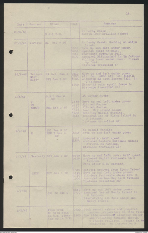
| Date | Courses | Winds | Time |
Remarks |
| 26/2/42 | At Derby Creek | |||
| N.E.1 B.C. | Native Crew drilling ashore | |||
| 27/2/42 | Various | N1 Sea 0 SC | At Derby Creek. Working on ships | |
| lauch. | ||||
| 1330 1400 1445 1500 |
Hove up and left under power. Reduced speed to half. Increased speed to full. Anchored Millingimbi in 2½ fathoms. |
|||
| Filling fresh water tank. Picked up fuel. Distance travelled 6' |
||||
| 28/2/42 | Various | N1 B.C. Sea 1 | 0610 | Hove up and left under power. |
| N50° | 0755 | Alt. Co 0635 Alt. Co. N158°E. | ||
| N158° | SE2 Sea 1 BC | 1105 | Anchored SE side Banyan Isld. in 9 | |
| fathoms. | ||||
| 1700 | Heavy SE rain squall force 5. | |||
| Distance travelled 34' | ||||
| 1/3/42 | S.E.1 Sea 0 | At Goyder River | ||
| BC | ||||
| N NE |
1155 1215 |
Hove up and left under power. Altered Course |
||
| N68°E | S E 2 Sea 2 BC | 1340 | Altered Course | |
| 1545 1600 1645 |
Sand Cay Island abeam Entering Cadell Straits. Anchored lee of Kicho Island in |
|||
| 3 fathoms. | ||||
| Distance travelled 28' | ||||
| 2/3/42 | SE1 Sea 0 BC | At Cadell Straits | ||
| E | ESE 2 Sea O | 1345 | Hove up and left under power. | |
| BC | ||||
| 1545 1635 |
Reduced to half speed Anchored Eastern Entrance Cadell |
|||
| Straits 4 fathoms. | ||||
| Distance travelled 15' | ||||
| 3/3/42 | Easterly | SE1 Sea C BC | 0640 | Hove up and left under half speed. |
| 0815 | Anchored Napier Peninsula in 3 | |||
| fathoms. | ||||
| Fine clear S.E weather. | ||||
| 1530 | Natives arrived from Elcho Island. | |||
| SEXE | SE1 Sea 1 BC | 1540 | Hove up and left under power. | |
| 1730 1900 |
Flinders Peninsula abeam Alt. C. Anchored Arnhem Bay in 2 fathoms |
|||
| Distance travelled 36' | ||||
| 4/3/42 | 0630 | Hove up and left under power. | ||
| SE1 BC Sea O | 0700 | Anchored lee of Hardy Island in | ||
| 3 fathoms. | ||||
| Discharging all deck cargo and heavy stores. |
||||
| 5/3/42 | Wind from | 0830 | Took vessel ashore and prepared | |
| NE with rain | [[?]] preparatory to tide falling | |||
| in a.m. clearing | 1400 | Low tide commenced cleaning copper | ||
| up in P.M. | and replacing damaged sheets. | |||
| 5 sheets replaced. Copper is [[?]] condition. On inspection 3 |
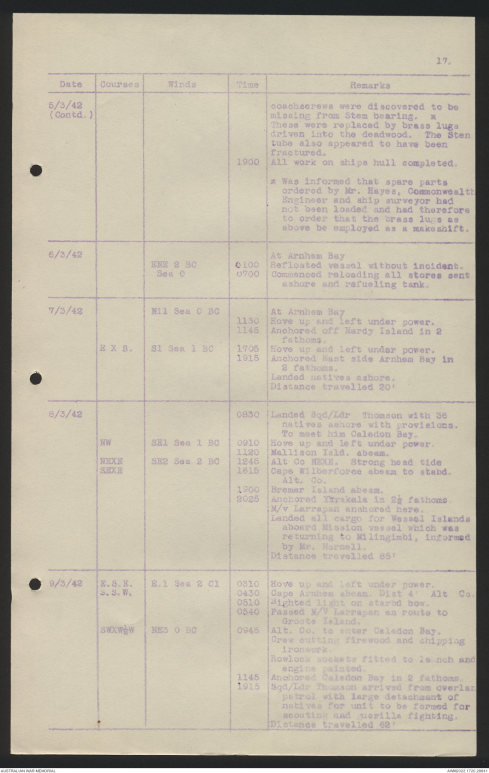
17.
| Date | Courses | Winds | Time |
Remarks |
| 5/3/42 | coachscrews were discovered to be | |||
| (Contd.) | missing from Sten bearing. * | |||
| These were replaced by brass lugs driven into the deadwood. The Sten tube also appeared to have been fractured. |
||||
| 1900 | All work on ships hull completed. | |||
| * Was informed that spare parts ordered by Mr. Hayes, Commonwealth Engineer and ship surveyor had not been loaded and had therefore to order that the brass lugs as above be employed as a makeshift. |
||||
| 6/3/42 | At Arnhem Bay | |||
| NNE 2 BC Sea C |
0100 0700 |
Refloated vessel without incident. Commenced reloading all stores sent |
||
| ashore and refuelling tanks. | ||||
| 7/3/42 | Nil Sea C BC | At Arnhem Bay | ||
| 1130 1145 |
Hove up and left under power. Anchored off Nardy Island in 2 |
|||
| fathoms. | ||||
| E X S. | S1 Sea 1 BC | 1705 | Hove up and left under power. | |
| 1915 | Anchored East side Arnhem Bay in | |||
| 2 fathoms. Landed natives ashore. Distance travelled 20' |
||||
| 8/3/42 | 0830 | Landed Sqn/Ldr Thomson with 36 | ||
| natives ashore with provisions. To meet him Caledon Bay. |
||||
| NW | SE1 Sea 1 BC | 0910 | Hove up and left under power. | |
| 1120 | Mallison Isld. abeam. | |||
| NEXE | SE2 Sea 2 BC | 1245 | Alt. Co. NEXE. Strong head tide. | |
| SEXE | 1615 | Cape Wilberforce abeam to stabd. | ||
| Alt. Co. | ||||
| 1900 | Bremer Island abeam. | |||
| 2025 | Anchored Yirrakala in 2½ fathoms. | |||
| M/v Larrapan anchored here. Landed all cargo for Wessel Islands aboard Mission vessel which was returning to Millingimbi, informed by Mr. Horsell. Distance travelled 65' |
||||
| 9/3/42 | E.S.E. | E.1 Sea 2 C1 | 0310 | Hove up and left under power. |
| S.S.W. | 0430 | Cape Arnhem abeam. Dist 4' Alt Co. | ||
| 0510 | Sighted light on starbd bow. | |||
| 0540 | Passed M/V Larrapan en route to | |||
| Groote Island. | ||||
| SWXW½W | NE3 O BC | 0945 | Alt. Co. to enter Caledon Bay. | |
| Crew cutting firewood and chipping ironwork. Rowlock sockets fitted to launch and engine painted. |
||||
| 1145 | Anchored Caledon Bay in 2 fathoms. | |||
| 1915 | Sqd/Ldr Thomson arrived from overland | |||
| patrol with large detachment of natives for unit to be formed for scouting and guerilla fighting. Distance travelled 62' |
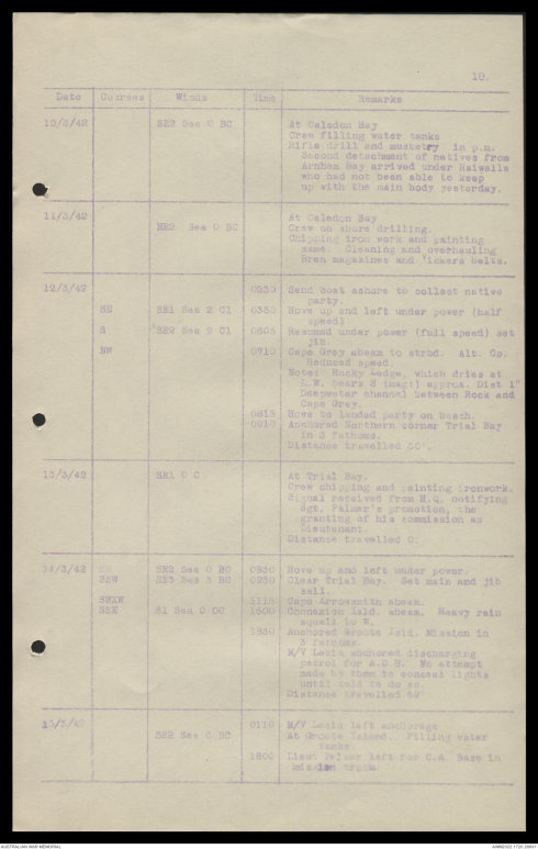
18.
| Date | Courses | Winds | Time | Remarks |
| 10/3/42 | SE2 Sea C BC | At Caledon Bay | ||
| Crew filling water tanks Rifle drill and musketry in p.m. Second detachment of natives from Arnhem Bay arrived under Raiwalla who had not been able to keep up with the main body yesterday. |
||||
| 11/3/42 | At Caledon Bay | |||
| NE2 Sea 0 BC | Crew on shore drilling. | |||
| Chipping iron work and painting same. Cleaning and overhauling Bren magazines and Vickers belts. |
||||
| 12/3/42 | 0230 | Sent boat ashore to collect native | ||
| party. | ||||
| SE | SE1 Sea 2 C1 | 0350 | Hove up and left under power (half | |
| speed) | ||||
| S | SE2 Sea 2 C1 | 0505 | Resumed under power (full speed) set | |
| jib. | ||||
| NW | 0710 | Cape Grey abeam to strbd. Alt. Co. | ||
| Reduced speed. Note: Rocky Ledge, which dries at L.W bears S (magt) approx. Dist. 1' Deepwater channel between Rock and Cape Grey. |
||||
| 0815 0910 |
Hove to landed party on beach. Anchored Northern Corner Trial Bay |
|||
| in 3 fathoms. Distance travelled 50' |
||||
| 13/3/42 | SE1 0 C | At Trial Bay. | ||
|
|
Crew chipping and painting ironwork. Signal received from H.Q. notifying Sgt. Palmer's promotion, the granting of his commission as Lieutenant. Distance travelled 0. |
|||
| 14/3/42 | SE2 Sea 0 BC | 0530 | Hove up and left under power. | |
| SWE | SE3 Sea 3 BC | 0950 | Clear Trial Bay. Set main and jib | |
| sail. | ||||
| SWXW | 1115 | Cape Arrowsmith abeam. | ||
| SSE | S1 Sea 0 OC | 1500 | Connexion Isld. abeam. Heavy rain | |
| squall in W. | ||||
| 1830 | Anchored Groote Isld. Mission in | |||
| 3 fathoms. M/V Lasia anchored discharging patrol for A.C. B. No attempt made by them to conceal lights until told to do so. Distance travelled 59' |
||||
| 15/3/42 | 0110 | M/V Lasia left anchorage. | ||
| SE2 Sea C BC | At Groote Island. Filling water | |||
| tanks. | ||||
| 1800 | Lieut Palmer left for C.A. Base in | |||
| Mission truck. |
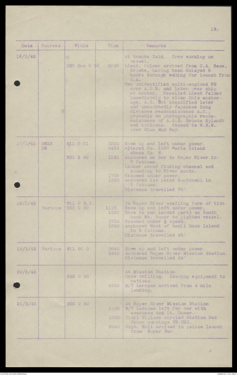
19.
| Date | Courses | Winds | Time | Remarks |
| 16/3/42 | At Groote Isld. Crew working on | |||
| vessel. | ||||
| SE3 0 BC | 2000 | Lieut. Palmer arrived from C.A. Base, | ||
| Groote, having been delayed 8 hours through waiting for launch from C.A. Two unidentified multi-engined FB over A.C.B. and later over ship at anchor. Recalled Lieut Palmer immediately to clear this anchorage. A.C. Not identified later and undoubtedly Japanese long distance reconnaissance A.C., probably on photographic reconnaissance of A.C.B. Groote Eylandt and environs. Passed to W.N.W. over Blue Mud Bay. |
||||
| 17/3/42 | SWXS | Nil 0 C1 | 0300 | Hove up and left under power. |
| SW | 0430 | Altered Co. 103° Maria Island | ||
| abeam Co. W. | ||||
| NE1 2 BC | 1140 | Anchored on Bar to Roper River in | ||
| 7 fathoms. Launch ahead finding channel and sounding to River mouth. |
||||
| 1705 1930 |
Resumed under power. Anchored 1st point Southbank in |
|||
| 3 fathoms. Distance travelled 75' |
||||
| 18/3/42 | Nil 0 B.C. | In Roper River awaiting turn of tide. | ||
| Various | SE 3 0 BC | 1115 | Hove up and left under power. | |
| 1630 | Hove to and landed party on South | |||
| bank Mt. Roper to lighten vessel. | ||||
| 1700 1800 |
Resumed under ½ speed. Anchored West of Small Rock Island |
|||
| in 6 fathoms. Distance travelled 45' |
||||
| 19/3/42 | Various | Nil BC 0 | 0640 | Hove up and left under power. |
| 0940 | Anchored Roper River Mission Station. | |||
| Distance travelled 24' | ||||
| 20/3/42 | At Mission Station | |||
| NE2 0 SC | Crew drilling. Issuing equipment to | |||
| natives. | ||||
| 2300 | M/V Larapan arrived from 4 mile | |||
| landing. | ||||
| 21/3/42 | NE2 0 SC | At Roper River Mission Station | ||
| 1100 | M/V Larapan left for bar with | |||
| evacuees and Lt. Dower. | ||||
| 1000 | Civil Biplane circled Station Red | |||
| Cross markings VE-UZC | ||||
| 2040 | Capt. Hall arrived in police launch | |||
| from Roper Bar |
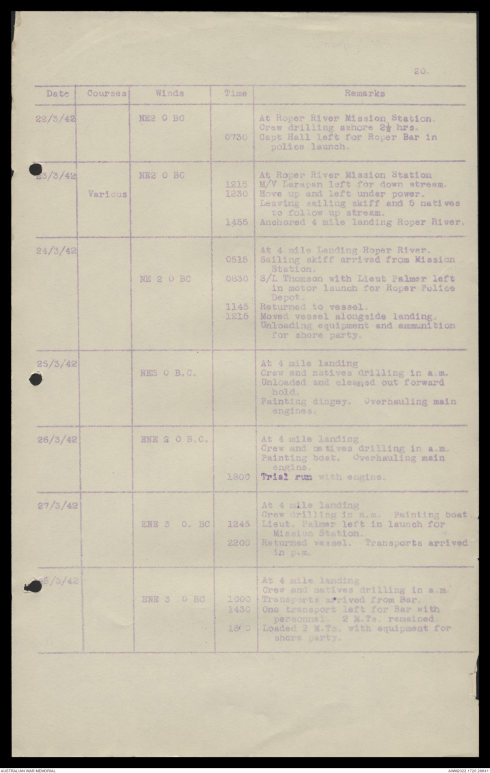
20.
| Date | Courses | Winds | Time | Remarks |
| 22/3/42 | NE2 0 BC | At Roper River Mission Station. | ||
| Crew drilling ashore 2½ hrs. | ||||
| 0730 | Capt Hall left for Roper Bar in | |||
| police launch. | ||||
| 23/3/42 | NE2 0 BC | At Roper River Mission Station | ||
| 1215 | M/V Larapan left for down stream. | |||
| Various | 1230 | Hove up and left under power. | ||
| Leaving sailing skiff and 5 natives to follow up stream. |
||||
| 1455 | Anchored 4 mile landing Roper River. | |||
| 24/3/42 | At 4 mile Landing Roper River. | |||
| 0515 | Sailing skiff arrived from Mission | |||
| Station. | ||||
| NE 2 0 BC | 0830 | S/L Thomson with Lieut Palmer left | ||
| in motor launch for Roper Police Depot. |
||||
| 1145 | Returned to vessel. | |||
| 1215 | Moved vessel alongside landing. | |||
| Unloading equipment and ammunition for shore party. |
||||
| 25/3/42 | At 4 mile landing | |||
| NE3 0 BC | Crew and natives drilling in a.m. | |||
| Unloaded and cleaned out forward hold. Painting dingey. Overhauling main engines. |
||||
| 26/3/42 | ENE 2 0 B.C. | At 4 mile landing | ||
| Crew and natives drilling in a.m. Painting boat. Overhauling main engine. |
||||
| 1800 | Trial run with engine. | |||
| 27/3/42 | At 4 mile landing | |||
| Crew drilling in a.m. Painting boat. | ||||
| ENE 3 0 B.C. | 1245 | Lieut Palmer left in launch for | ||
| Mission Station. | ||||
| 2200 | Returned vessel. Transports arrived | |||
| in p.m. | ||||
| 28/3/42 | At 4 mile landing | |||
| Crew and natives drilling in a.m. | ||||
| ENE 3 0 B.C | 1000 | Transports arrived from Bar. | ||
| 1430 | One transport left for Bar with | |||
| personnel. 2 M.Ts remained. | ||||
| 1840 | Loaded 2 M.Ts with equipment for | |||
| shore party. |
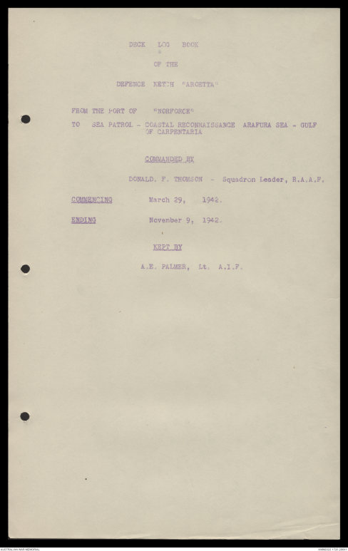
DECK LOG BOOK
OF THE
DEFENCE KETCH "AROETTA"
FROM THE PORT OF "NORFORCE"
TO SEA PATROL - COASTAL RECONNAISSANCE ARAFURA SEA - GULF
OF CARPENTARIA
COMMANDED BY
DONALD. F. THOMSON - Squadron Leader, R.A.A.F.
COMMENCING March 29, 1942.
ENDING November 9, 1942.
KEPT BY
A.E. PALMER, Lt. A.I.F.
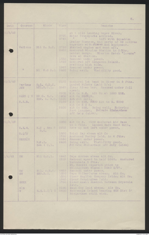
2.
| Date | Courses | Winds | Time | Remarks |
| 29/3/42 | At 4 mile landing Roper River. | |||
| 0700 0745 |
Motor transports arrived. " " left with Squadron |
|||
| Leader Thomson, and party of 50 natives |
||||
| together with stores and equipment. | ||||
| Various | Nil 0. B.C. | 0750 | Started engine and cast off. | |
| 0935 | Anchored Mission Station in 3 fths. | |||
| Landed cargo. Mission Ketch "Iorena" here at Station. |
||||
| 1330 1810 |
Resumed under power. Anchored off Kangaroo Island. |
|||
| Awaiting high tide. | ||||
| 1945 | Resumed under power. | |||
| " | NE 2.0 B.C. | 2400 | Going well. Visibility good. | |
| 30/3/42 | 0100 | Anchored first Bend in river in 5 fths. | ||
| Various | Ni1. C.B.C. | Landed pilots (paid 3/-) | ||
| NE | NET.B.C.1 | 0845 | Clear River bar. Resumed under full | |
| speed. | ||||
| 0900 | Alt. Co. N.E. Alt Co at 1000 ENE. | |||
| NE C. B.C. | 1200 | Alt Co NEXN½N. | ||
| SE2. 1. B.C. | 1400 | Set All sail. | ||
| N.X.E. | 2140 | Alt Co NXE. 2300 Alt to E. 2350 | ||
| Alt Co E X S. | ||||
| 2400 | Alt Co ESE. Going well. Entering | |||
| Fort Langdon. Private Richardson off duty (sick). |
||||
| 31/3/42 | 0020 | Alt Co S. 0100 Anchored Air Base | ||
| in [[?]] fths. Landed Safe Hand Mail. | ||||
| N.X.W. | N.2 . Sea 1 | 0915 | Hove up and left under power. | |
| B.C. | ||||
| N. B.C/1/4 E | 1530 | Trial Bay abeam Alt Co | ||
| 1700 | Anchored Dudley Isld. in 4 fths. | |||
| HEXH | 2330 | Resumed under power. | ||
| N.E.1. | 2400 | Going well. Visibility good. | ||
| Sea 1 C.1. | Private Richardson off duty (sick) | |||
| 1/4/42 | NW | Nil O.C.1 | 0445 | Cape Arnhem abeam Alt Co. |
| 0515 | Reduced speed to half 0545. Anchored | |||
| Yarrakala 5 fths. Mt. Howell reported pilot to [[Milingsbush?]] Signal: 2240 Z/27. |
||||
| NW SW |
Nil. O.B.C. SE2. B.C. |
0825 1000 |
Resumed under power. Cape Wilberforce abeam. Alt Co. |
|
| 1330 1645 |
Clear English Company Islds. Alt Co. Clear Cunningham Isld. |
|||
| 3NXX | 1730 | Clear small channel between Drysdale | ||
| Isld. | ||||
| W½S | 2100 | Sand Cay Isld. abeam. Alt Co. | ||
| W | S.E.1 0/1 2 | 2400 | Mooroonga Island bearing WXN Dist 5' | |
| Richardson still sick. |
Last edited by:
 Deb Parkinson
Last edited on:
This transcription item is now locked to you for editing. To release the lock either Save your changes or Cancel.
This lock will be automatically released after 60 minutes of inactivity.