Written Records, AWM54 741/5/9 PART 2 - [Patrols - Reconnaissance:] Report on Northern Territory Special Reconnaissance Unit, by Sqn Ldr D F Thomson RAAF [Report minus maps] - Part 21
SECRET 13.
APPENDIX IV.
A.K Aroetta,
Caledon Bay,
Arnhem Land.
Date: August 11th, 1942
FOR: ADVANCED HEADQUARTERS, NORTHERN TERRITORY FORCE
FROM: O.C. SPECIAL RECONNAISSANCE UNIT.
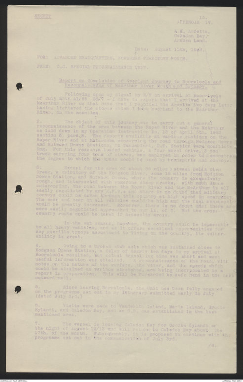
Report on Completion of Overland Journey Borroloola and
Reconnaissance of McArthur River Mouth and Estuary
Following upon my signal by W/T on arrival at Borroloola
of July 25th A1/55. I have to report that I arrived at the
McArthur River on that date that I rejoined the Aroetta two days later
having lightered the stores which I took overland to the McArthur
River, in the meantime.
2. The object of this journey was to carry out a general
reconnaissance of the area between the Roper River and the McArthur
as laid down in my Operational Instruction No. 13 of April 5th. 1942
section 3, para. B. The reports available at various stations on the
Roper River and at Mataranka concerning the road through Hodgson Downs
and Nutwood Downs Stations, to Tanumbirini D. T. Station were conflicting.
For this reason a loaded vehicle, a four wheel drive, 3 ton
truck carrying four tons of stores, was employed in order to demonstrate
the degree to which the track could be used by transports and convoys.
3. Except for the area of about 33 miles between Bella Glen
Creek, a tributary of the Hodgson River, some 15 miles from Hodgson
Downs Station, and Nutwood Downs, where the country is excessively
rough, and intersected with numerous steep creeks, with much stone
outcropping, the road between the Roper River and the McArthur is all
easily negotiated by any A.F.V.s and there is no doubt that military
convoys could be taken through this country at high speed in emergency.
The wear and tear on all vehicles would be high and the fuel consumption
would be greatly increased. However, there is no doubt that there are
more easily negotiated approaches to our Ls of C. But the cross-country
route could be taken if necessity arose.
In the wet season, however the country would be impassable
to all heavy vehicles and would offer excellent opportunities for
any guerrilla troops accustomed to living in the country, its
vulnerability is great.
4. Owing to a broken strut axle which was sustained close to
Hodgson Downs Station, a delay of nearly ten days in my arrival at
Borroloola resulted, but actual travelling time was short and much
useful information was obtained. A reconnaissance of the road, with
notes on the nature of the surface, the water and the speeds which
could be attained on various stretches, are being incorporated in a
report in preparation. This will be forwarded by safe hand in the next
outward mail.
5. Since leaving Borroloola, the unit has been fully engaged on the
programme set out in my Itinerary submitted early in July
(dated July 3rd.)
6. Visits were made to Vanderlin Island, Maria Island, Groote
Eylandt and Caledon Bay, and an O.P. was established in the last
mentioned area.
7. The vessel is leaving Caledon Bay for Groote Eylandt on
the night of August 12/13 and will return to Caledon Bay about the
17th of the month. Subsequently, it is proposed to continue with the
programme set out in the communication of July 3rd.
SECRET.
14
APPENDIX IV
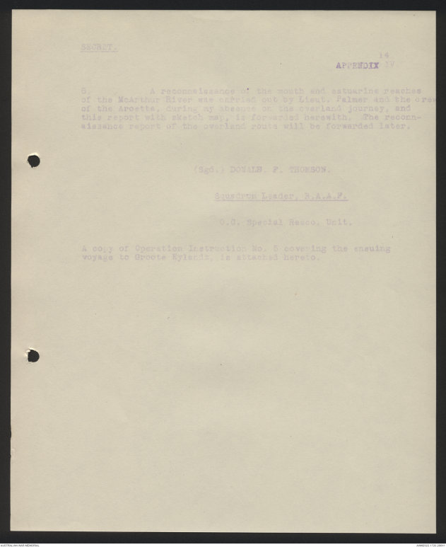
8. A reconnaissance of the mouth and estuarine reaches
of the McArthur River was carried out by Lieut. Palmer and the crew
of the Aroetta, during my absence on the overland journey, and
this report with sketch map, is forwarded herewith. The
reconnaissance report of the overland route will be forwarded later.
(Sgd,)DONALD,. F. THOMSON
Squadron Leader R.A.A.F.
O.C. Special Recce. Unit.
A copy of the Operation Instruction No.5 covering the ensuring
voyage to Groote Eylandt is attached hereto.
SECRET.
15.
APPENDIX IV.
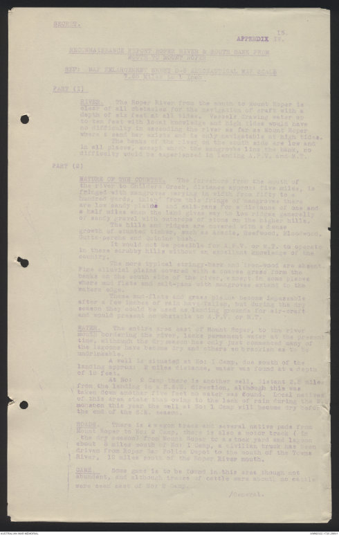
RECONNAISSANCE REPORT ROPER RIVER & SOUTH BANK FROM
MOUTH TO MOUNT ROPER
REF: MAP ENLARGEMENT SHEET D-5 AERONAUTICAL MAP SCALE
7.85 Miles to 1 Inch .
PART (1)
RIVER. The Roper River from the mouth to Mount Roper is
clear of all obstacles for the navigation of craft with a
depth of six feet at all tides. Vessels drawing water up
to ten feet with local knowledge and high tides would have
no difficulties in ascending the river as far as Mount Roper
where a sand bar exists and is only navigable at high tides.
The banks of the river on the south side are low and
in all places , except where the mangroves line the bank, no
difficulty would be experienced in landing A.F.V. and M.T.
PART (2)
NATURE OF THE COUNTRY. The foreshore from the south of
the river to Childers Creek, distance approx: five miles, is
fringed with mangroves varying in width from fifty to a
hundred yards, inland from this fringe of mangroves there
are low sandy plains and salt pans for a distance of one and
a half miles when the land gives way to low ridges generally
of sandy gravel with outcrops of stone on the higher hills.
The hills and ridges are covered with a dense
growth of stunted timber, such as Acacia, Beefwood, Blackwood,
Gutta-percha and Quinine bush.
It would not be possible for A.F.V. or M.T. to operate
in these scrubby hills without a excellent knowledge of the
country.
The more typical stringy-bark and ironwood are absent.
Fine alluvial plains covered with a coarse grass form the
banks on the south side of the river, except in some places
where mud flats and salt-pans with mangroves extend to the
waters edge.
These mud-flats and grass plains become inaccessible
after a few inches of rain have fallen, but during the dry
season they could be used as landing grounds for air-craft
and would present no obstacle to A.F.V. or M.T.
WATER. The entire area east of Mount Roper, to the river
mouth bordering the river, lacks permanent water at the present
time, although the dry has only just commenced many of
the lagoons have became dry and others so brackish as to be
undrinkable.
A well is situated at No: 1 Camp, due south of the
landing approx: 2 miles distance, water was found at a depth
of 18 feet.
At No: 2 Camp there is another well, distant 2.6 miles
from the landing in a S.S.E. direction, although this was
taken down another five feet no water was found. Local natives
of this area state that owing to the lack of rain during the last
monsoon this year the well at No: 1 Camp will become dry before
the end of the S:E. season.
ROADS. There is a wagon track and several native pads from
Mount Roper to No: 2 Camp, there is also a motor track ( in
the dry season) from Mount Roper to a stock yard and lagoon
about 8 miles south of No: 1 Camp, a civilian truck has been
driven from Roper Bar Police Depot to the south of the Towns
River, 18 miles south of the Roper River Mouth.
GAME. Some game is to found in this area though not
abundant, and although traces of cattle were about no cattle
were seen east of No: 2 Camp.
/ General.
SECRET.
16.
APPENDIX IV
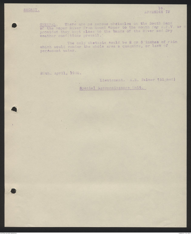
GENERAL. There are no serous obstacles on the South Bank
of the Roper River from Mount Roper to the mouth for A.F.V. or M.T.
provided they kept close to the banks of the River and Dry
weather conditions prevail.
The only obstacle could be 2 or 3 inches of rain
which would render the whole area a quagmire, or lack
of permanent water.
28th. April 1942
Lieutenant A.E. Palmer (Signed)
Special Reconnaissance Unit.
SECRET
17.
APPENDIX IV
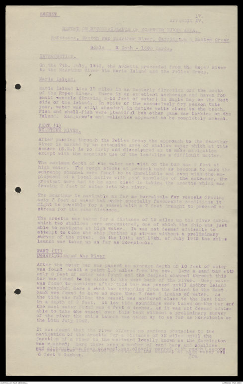
REPORT ON RECONNAISSANCE OF MCARTHUR RIVER AREA.
Reference, Sketch Map, McArthur River, Carrington & Batten Creek
Scale X Inch - 1000 Yards.
INTRODUCTION.
On the 7th July 1942, the Aroetta proceeded from the Roper River
to the McArthur River via Maria Island and the Pellew Group.
Maria Island.
Maria Island lies 15 miles in an Easterly direction off the mouth
of the Roper River. There is an excellent anchorage and haven for
small vessels (Drawing 6-10 feet of water) in Eagle Bay on the West
side of the Island. In spite of the excessively dry season this
year, water was still abundant in native wells close to the beach.
Fish and shell-fish were plentiful but other game was lacking on the
island. Kangaroo's and wallabies appeared to be completely absent.
PART (I)
MCARTHUR RIVER.
After passing through the Pellew Group the approach to the McArthur
River is marked by an extensive area of shallow water which at this
season (S.E.) is so dirty and discoloured as to make navigation
except with the constant use of the lead-line a difficult matter.
The minimum depth of the water met with on the bar was 9 feet at
high water. The rough stakes at present used as beacons to mark the
entrance channel were found to be unreliable and even with the
employment of a local native with a good knowledge of the entrance, the
greatest care had to be exercised in taking the Aroetta which was
drawing 3 feet of water into the river.
The McArthur is navigable as far as Borroloola for vessels drawing
only 5 feet of water but under specially favourable conditions it
might be possible for a vessel with 7 foot draught to proceed up
stream for the same distance.
The Aroetta was taken for a distance of 18 miles up the river during
which two shallows were encountered, one of which the ship was just
able to navigate at high water. It was not deemed advisable to
attempt to take the ship further up stream without a preliminary
survey of the river. On the 10th and 15th of July 1942 the ships
launch was taken up as far as Borroloola.
Part (II)
Description of the River
After the outer bar was passed an average depth of 10 feet of water
was found until a point 1.5 miles from the sea. Here a sand bar with
only 8 feet of water was found and the deepest channel through this
bar was found to be close to the west bank of the river. Deep water
was found to continue after this bar was passed until Anchor Island
was reached, here a sand bar extending from the Island to the East
bank was found to have no more than 7 foot 6inches of water. As
the tide was falling the vessel was anchored close to the East bank
in a depth of 8 feet. At low tide soundings were taken on the bar and
the most water found was 4 feet 6 inches. As it was not deemed
advisable to take the vessel over this bank without a preliminary survey
of the river the ships launch was taken up to as far a Borroloola on
the 10th July 1942.
It was found that the river offered no serious obstacles to the
navigation of the Aroetta for a distance of 12 miles until the
junction of a river to the westward locally known as the Carrington
was reached; here there were a number of sand bars and shallows
and although the deep channel was clearly marked with rough beacons
the most water that could be found in the channel at high water was
6 feet 5 inches.
/on
SECRET.
18.
APPENDIX IV.
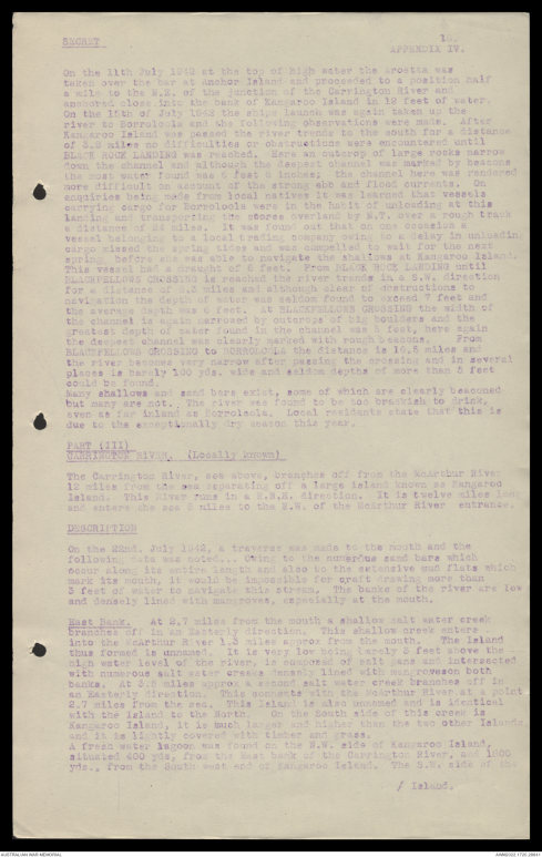
On the 11th July 1942 at the top of high water the Aroetta was
taken over the bar at Anchor Island and proceeded to a position half
a mile to the N.E. of the junction of the Carrington River and
anchored close into the bank of Kangaroo Island in 18 feet of water.
On the 15th of July 1942 the ships launch was again taken up the
river to Borroloola and the following observations were made. After
Kangaroo Island was passed the river trends to the south for a distance
of 3.8 miles no difficulties or obstructions were encountered until
BLACK ROCK LANDING was reached. Here an outcrop of large rocks narrow
down the channel and although the deepest channel was marked by beacons
the most water found was 6 feet 8 inches; the channel here was rendered
more difficult on account of the strong ebb and flood currents. On
enquiries being made from local natives it was learned that vessels
carrying cargo for Borroloola were in the habit of unloading at this
landing and transporting the stores overland by M.T. over a rough track
a distance of 24 miles . It was found out that on one occasion a
vessel belonging to a local trading company owing to a delay in unloading
cargo missed the spring tide and was compelled to wait for the next
spring before she was able to navigate the shallows at Kangaroo Island.
This vessel had a draught of 8 feet. From BLACK ROCK LANDING until
BLACKFELLOWS CROSSING is reached the river trends in a S.W. direction
for a distance of 2.3 miles and although clear of obstructions to
navigation the depth of water was seldom found to exceed 7 feet and
the average depth was 6 feet. At BLACKFELLOW CROSSING the width of
the channel is again narrowed by outcrops of big boulders and the
greatest depth of water found in the channel was 5 feet, here again
the deepest channel was clearly marked with rough beacons. From
BLACKFELLOW CROSSINGS to BORROLOOLA the distance is 10.5 miles and
the river becomes very narrow after passing the crossing and in several
places is barely 100 yds. wide and seldom depths of more than 5 feet
could be found.
Many shallows and sand bars exist, some of which are clearly beaconed
but many are not. The river was found to be too brackish to drink,
even as far inland as Borroloola. Local residents sate that this is
due to the exceptionally dry season this year.
PART (III)
CARINGTON RIVER (Locally known)
The Carrington River, see above, branches off from the McArthur River
12 Miles from the sea separating off a large island known as Kangaroo
Island. This River runs in a E.N.E. direction. It is twelve miles long
and enters the sea 8 miles to the N.W. of the McArthur River entrance.
DESCRIPTION
On the 22nd. July 1942, a traverse was made to the mouth and the
following data was noted. . . Owing to the numerous sand bars which
occur along its entire length and also to the extensive mud flats which
mark its mouth, it would be impossible for craft drawing more than
3 feet of water to navigate this stream. The banks of the river are low
and densely lined with mangroves, especially at the mouth.
East Bank. At 2.7 miles from the mouth of a shallow salt water creek
branches off in an Easterly direction. This shallow creek enters
into the McArthur River 1.3 miles approx from the mouth. The Island
thus formed is unnamed. It is very low being barely 3 feet above the
high water level of the river, is composed of salt pans and intersected
with numerous salt water creeks mainly lined with mangroves on both
banks. At 3.5 miles approx a second salt water creek branches off in
an Easterly direction. This connects with the McArthur River at the point
2.7 miles from the sea. This Island is also unnamed and is identical
with the island to the North. On the South side of this creek is
Kangaroo Island, it is much larger and higher than the two other Islands
and it lightly covered with timber and grass.
A fresh water lagoon was formed on the N.W. side of Kangaroo Island,
situated 400 yds, from the East bank of the Carrington River, and 1800
yds. . from the South west end of Kangaroo Island. The S.W. side of the
/ Island.
SECRET.
19.
APPENDIX IV.
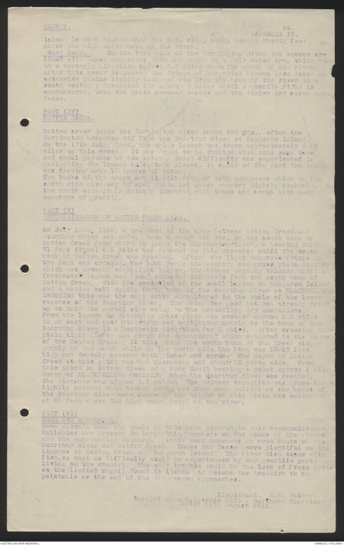
Island is much higher than the N.E. side, being nearly twenty feet
above the high water mark of the river.
West Bank. On the N.W. bank of the Carrington River the shores are
lined with dense mangroves from the south to a salt water arm, which runs
in a westerly direction approx. 3.8 miles from the mouth of the river.
After this creek is passed the fringe of mangroves become less dense and
extensive plains lightly timbered run from the bank of the river in a
south westerly direction for approx 4 miles until a granite ridge is
encountered, when the grass becomes scarce and the timber and scrub more
dense.
PART (IV)
BATTEN CREEK.
Batten creek joins the Carrington River about 500 yds., after the
Carrington branches off from the McArthur River at Kangaroo Island.
On the 17th July 1942, the ships launch was taken approximately 9-10
miles up this creek. It was found to be shallow with many sand bars
and shoal patches at low water. Great difficultly was experienced in
navigating the launch in certain places, in spite of the fact the launch
was drawing only 12 inches of water.
The banks of the creek are lightly fringed with mangroves which on the
south side give way to open plain and grass country lightly timbered. On
the north side it is lightly timbered with trees and scrub with many
outcrops of granite.
PART (V)
RECONNAISSANCE OF BATTEN CREEK AREA.
On July 18th, 1942, a traverse of the area between Batten Creek and
McArthur River was made. From a point 400 yds. to the south bank of
Batten Creek from where it joins the Carrington River, a bearing North
71 degs (True) 6.5 miles was covered on this traverse until the south
bank of Batten Creek was reached. After the light mangrove fringe on
the bank was crossed, for 1000 yards the country was grass plain country
which was covered with light timber, the timber getting thinner until a
freshwater lagoon was found situated 250 yards from the south bank of
Batten Creek. With the exception of a small lagoon on Kangaroo Island
and a native well on the North bank of the McArthur River at BLACKFELLOW
CROSSING this was the only water encountered in the whole of the lower
reaches of the McArthur River. The water was good but had already dried
up to half its normal size owing to the prevailing dry conditions.
From the lagoon an extensive grass plain was crossed approx 2.5 miles
in an east and west direction and continuing nearly to the bank of the
McArthur River in a Southerly direction for 5 miles. After crossing this
plain light timber and scrub was encountered which extended to the banks
of the Batten Creek. At this point the south bank of the Creek sloped
gently to the water while on the north side of the bank was 10-15 feet
high and densely covered with timber and scrub. The depth of Batten
Creek at this point was 3-5 feet deep and about 30 yards wide. From
this point on Batten Creek on a true South bearing a point approx 1 mile
North of BLACKFELLOW CROSSING when the McArthur River was reached,
the distance was approx. 6.3 miles. The country travelled was grass land
lightly covered with timber being cut into many gullies as the banks of
the McArthur River were [[spared?]] the height of this plain was estimated
at 25 feet above the high water level of the river.
PART (VI)
GAME AND RESOURCES
Game abounds over the whole of this area covered in this reconnaissance.
Wallabies are present in incredible numbers on the banks of the rivers
and the surrounding country. Cattle were numerous on both banks of the
McArthur River and Batten Creek. Ducks and Geese were plentiful on the
lagoons at Batten Creek and Kangaroo Island. The river also teams with
fish, so that no difficulty would be experienced by any guerilla party
living on the country. The only trouble would be the lack of fresh water
as the limited supply found is liable to become too brackish to be
palatable as the end of the dry season approaches.
Lieutenant A.H. Palmer
Special Reconnaissance Unit - Northern Territory
Dated 11th August 1942
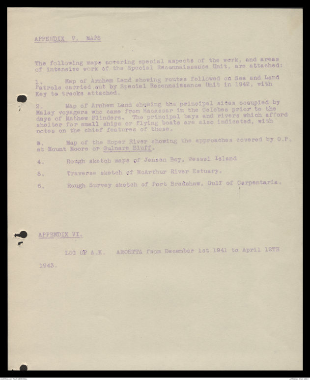
APPENDIX V. MAPS
The following maps covering special aspects of the work, and areas
of intensive work of the Special Reconnaissance Unit are attached:
1. Map of Arnhem Land showing routes on Sea and Land
Patrols carried out by Special Reconnaissance Unit in 1942, with
Key to tracks attached.
2. Map of Arnhem Land showing principal sites occupied by
Malay voyagers who came from Macassar in the Celebes prior to the
days of Mathew Flinders. The principal bays and rivers which afford
shelter for small ships or flying boats are also indicated, with
notes on the chief features of these.
3. Map of the Roper River showing the approaches covered by O.P.
at Mount Moore or Gulnare Bluff.
4. Rough sketch maps of Jensen Bay, Wessel Island
5. Traverse sketch of McArthur River Estuary.
6. Rough Survey sketch of Port Bradshaw, Gulf of Carpentaria.
APPENDIX VI
LOG OF A.K. AROETTA from December 1st 1941 to April 12TH
1943
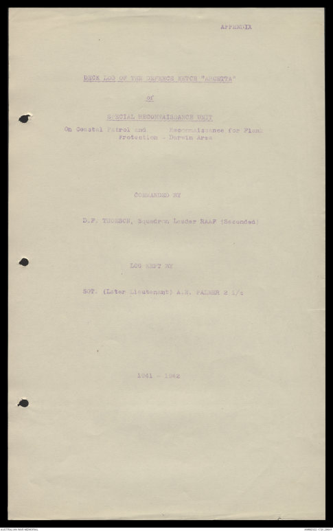
APPENDIX
DECK LOG OF THE DEFENCE KETCH "AROETTA"
of
SPECIAL RECONNAISSANCE UNIT
On Coastal Patrol and Reconnaissance for Flank
Protection - Darwin Area
COMMANDED BY
D.F. THOMSON, Squadron Leader RAAF (Seconded)
LOG KEPT BY
SGT. (Later Lieutenant) A.H. PALMER 2 i/c
1941 - 1942
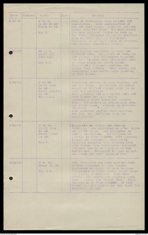
| Date | Courses | Winds | Time | Remarks |
| 1/12/41 | E to NE | Work on installing main engines and | ||
| Light in AM Fresh in PM |
auxiliaries. Also installation of oil and fuel pipes. Painting all new |
|||
| timber with red lead. Two carpenters | ||||
| Sky B | who were employed failed to turn up | |||
| for work. Reported matter to Interior. Main standing rigging completed. Timbering in of fuel tanks in progress and plumber installing piping. |
||||
| 2/12/41 | NE to N. | Main engines correctly aligned and | ||
| Light and variable. | fastened down. Engineers on fuel and air piping. Two Carpenters reported |
|||
| for work at 1300 hrs. Commenced work | ||||
| Sky O.C. | on outer cabin and chart house. | |||
| Shipwrights finished scuttles and engine room hatches. Crew oiling and varnishing main cabin; also painting 16 foot launch. |
||||
| 3/12/41 | N to NW. | Engineers working on main engines, air | ||
| Light airs in the AM. Heavy squalls in PM. Sky O.C.R. |
and oil lines. Shipwright commenced repairing 12 foot dingey which is in very bad condition. Crew painting all new timber work and also launch and main cabin. |
|||
| Installing water tanks and service tank. Carpenters on mizzen mast step and chart house. Plumber on lavatory fittings. Wire received stating crew arriving 5th Dec. 41. Definite reply re refrigerator. |
||||
| 4/12/41 | N to NE. | Engineers on piping and exhaust | ||
| Light airs in the AM. Heavy rains in PM. |
fittings. One carpenter on after cabin and chart house. One carpenter on awing stanchions. Shipwrights repairing 12 foot dinghey. Crew painting |
|||
| launch and varnishing main cabin. | ||||
| Sky C. | Notified Interior that natives from | |||
| Palm Island were terminating contract tomorrow and to be returned to the Settlement. Transport to pick up Sgt. Elkington and crew arranged for. |
||||
| 5/12/41 | N to NE. | Sgt. Elkington and crew arrived 0625. | ||
| Fresh in PM. | Natives returned to Palm Island. | |||
| Engineers on piping of main engines. | ||||
| Sky B.C. | Carpenters on after cabin, chart house | |||
| and awning stanchions. Crew overhauling | ||||
| all blocks and painting same. | ||||
| Drew blankets for Native Crew. Shipwrights | ||||
| on 12 foot dinghey. 16 foot launch painted inside and out ready for replacing engine. |
 Deb Parkinson
This transcription item is now locked to you for editing. To release the lock either Save your changes or Cancel.
This lock will be automatically released after 60 minutes of inactivity.